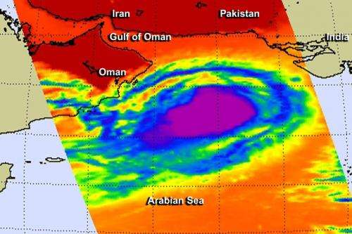
NASA takes Tropical Cyclone Nanuak's temperature

Tropical Cyclone Nanauk is holding its own for now as it moves through the Arabian Sea. NASA's Aqua satellite took its cloud top temperatures to determine its health.
In terms of infrared data viewing tropical cyclones, those with the coldest cloud top temperatures indicate that a storm is the most healthy, most robust and powerful. That's because thunderstorms that have strong uplift are pushed to the top of the troposphere where temperatures are bitter cold. Infrared data, such as that collected from the Atmospheric Infrared Sounder (AIRS) instrument that flies aboard NASA's Aqua satellite can tell those temperatures. If AIRS data shows that cloud top temperatures are near or colder than -63 Fahrenheit (-53 Celsius), that indicates strong thunderstorms high up in the troposphere. According to research with AIRS data, thunderstorms with cloud top temperatures that high are likely to generate heavy rainfall.
So, when Aqua flew over Tropical Cyclone Nanauk on June 12 at 9:11 UTC (5:11 a.m. EDT) temperatures of the many thunderstorms that circled the center of Nanauk were that cold or colder. The AIRS image also showed a band of thunderstorms that almost completely circled the storm, with the exception of the southwestern quadrant. Nanauk also seemed to fill up the northern part of the Arabian Sea.
On June 12 at 1500 UTC (11 a.m. EDT), Tropical Cyclone Nanauk was located approximately 425 nautical miles (489 miles/787 km) southeast of Muscat, Oman, near 18.3 north latitude and 63.4 east longitude. Nanauk was moving to the west at 10 knots (11.5 mph/18.5 kph). Maximum sustained winds remained near 55 knots (63.2 mph/102 kph).
Nanauk faces several challenges over the next couple of days, according to the Joint Typhoon Warning Center. Three factors will weaken the system quickly: increasing vertical wind shear, dry air moving into the tropical cyclone and cooler sea surface temperatures.
Nanauk is forecast to continue tracking west-northwestward over the next day or two before succumbing to a more hostile environment.
Provided by NASA's Goddard Space Flight Center


