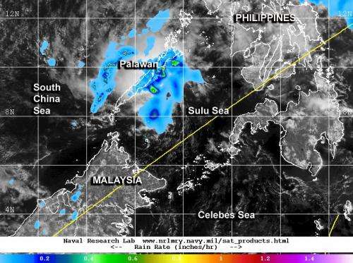
NASA sees Tropical Depression 04W's remnants affecting Palawan

Tropical Depression 04W formed in the Northwestern Pacific Ocean on March 23 and marched across the southern Philippines. NASA's TRMM satellite spotted moderate rainfall occurring near Palawan the next day from the storm's remnants.
Formerly known as System 94W, the tropical low organized into Tropical Depression 04W (TD04W) on Sunday, March 23. TD04W then crossed through the southern and central Philippines on March 22 and 23, moving from east to west through Mindanao and Visayas. At 04:32 UTC/12:32 a.m. EDT the depression had maximum sustained winds near 20 knots/23.0 mph/37.0 kph. At that time, TD04W was centered near 9.3 north and 124.6 east, about 225 nautical miles/258.9 miles/416.7 km northeast of Zamboanga, Philippines and moving in a westerly direction.
By March 24, the depression had weakened to a remnant low pressure area and was moving through the Sulu Sea. At 0600 UTC/2 a.m. EDT, TD04W was centered near 9.1 north latitude and 119.4 east longitude, about 50 nautical miles/57.5 miles/92.6 km southeast of Puerto Princesa, Palawan and bringing rainfall to the island of Palawan. Palawan is an island province of the Philippines in the Mimaropa region.
The Joint Typhoon Warning Center noted that maximum sustained surface winds were estimated at 10 to 15 knots/11.5 to 17.2 mph/ 18.5 to 27.7 kph. Minimum sea level pressure was estimated to be near 1009 millibars. There were no watches or warnings posted for Palawan on March 24.
The Tropical Rainfall Measuring Mission or TRMM satellite showed that the heaviest rainfall was occurring over the Sulu Sea and just off the coast of Aborlan (a municipality) and Puerto Princessa, the seat of government for Palawan. TRMM identified rainfall rates of up to 1.2 inches/30.4 mm per hour. A microwave image from TRMM also showed that the low has poor convective structure with an ill-defined low-level center.
The Joint Typhoon Warning Center expects the remnants of 04W to continue moving in a west-southwesterly direction into the South China Sea. However, because of atmospheric conditions, there is a low chance that the remnant will re-organize into a depression over the next couple of days.
Provided by NASA's Goddard Space Flight Center


