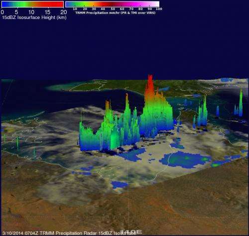
NASA saw some power in Tropical Cyclone Gillian before making landfall

NASA's TRMM satellite saw some towering thunderstorms in Tropical Cyclone Gillian before it made landfall over the Western Cape York Peninsula of Queensland, Australia. Gillian has been staying over land since, and is now a remnant low pressure area.
On March 10, NASA and JAXA's Tropical Rainfall Measuring Mission satellite called TRMM passed over Tropical Cyclone Gillian. TRMM's Precipitation Radar (PR) instrument gathered data that showed some of the powerful storms within tropical storm Gillian reached heights above 16 km/9.9 miles.
Tropical Cyclone Gillian's center still remained over land on March 11 at 0300 UTC. Maximum sustained winds were near 35 knots/40 mph/62 kph. Gillian was centered near 15.5 south and 141.7 east, over the Western Cape York Peninsula of Queensland and still 163 nautical miles/187.6 miles/301.9 km east-northeast of Mornington Island, Australia. It was moving to the south at 5 knots/5.7 mph/9.2 kph. The Joint Typhoon Warning Center issued their final advisory on Gillian at 0300 UTC.
By 1200 UTC/8 a.m. EST on March 11, the Joint Typhoon Warning Center or JTWC noted that Gillian had become a remnant low pressure area. An area of convection persisted near 15.6 south and 141.1 east, about 100 nautical miles/115.1 miles/185.2 km east-northeast of Mornington Island.
The JTWC noted that animated infrared imagery showed that the convection over the weak low-level circulation was poorly organized. Radar imagery showed that bands of thunderstorms were fragmented over the northwestern quadrant of the low pressure area.
Surface observations today (March 11) from Mornington Island and Kowanyama showed light winds (less than 10 knots/11.5 mph/18.5 kph) and sea level air pressure values near 1009 millibars. Maximum sustained surface winds were estimated at 15 to 20 knots/17.2 to 23.0 mph/27.7 to 37.0 kph. JTWC noted that the potential for the re-development into a tropical depression or tropical storm is low over the next day.
The Australian Bureau of Meteorology does not have any current warnings in place for Gillian's remnants, but cautioned, "People from Burketown to the QLD/NT (Queensland/Northern Territory) border, including Mornington Island and Sweers Island should consider what action they will need to take if the cyclone threat increases."
Provided by NASA's Goddard Space Flight Center


