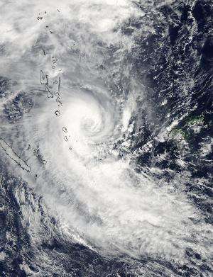
NASA sees Tropical Cyclone Lusi over Vanuatu

Tropical Cyclone Lusi reached hurricane force as NASA's Aqua satellite passed overhead early on March 12.
The Moderate Resolution Imaging Spectroradiometer or MODIS instrument aboard NASA's Aqua satellite captured a visible image of Tropical Cyclone Lusi that showed the storm's western quadrant affecting Vanuatu on March 12 at 02:05 UTC. In the MODIS image, Lusi had the distinct comma shape of a mature tropical cyclone, however no eye was visible. However, animated multispectral satellite imagery does show a ragged eye with tightly curved bands of thunderstorms wrapping into it.
At 11 a.m. EDT/1500 UTC on March 12, the Vanuatu Meteorological Service's forecast noted "Heavy rain and thunder with flooding associated with [Tropical Cyclone] Lusi will continue to affect Shefa and Tafea provinces. Gale to storm clockwise winds for Shefa and Tafea province, while fresh trades prevail elsewhere." A Severe Weather Warning remained in effect that noted showers and thunderstorms with heavy rainfall is expected over Northern and Central Islands with inland winds of 40km/h to 50km/h. Flash flooding is also expected over low lying areas and areas close to the river banks. For updates from the Vanuatu Met Service, visit: http://www.meteo.gov.vu.
On March 12 at 0900 UTC/5 a.m. EDT, Tropical Cyclone Lusi's maximum sustained winds were at 65 knots/74.8 mph/120.4 kph. Tropical-storm-force winds extend out about 80 nautical miles/92.0 miles/148.2 km from the center. Lusi was centered near 18.2 south latitude and 171.5 east longitude, about 395 nautical miles/454.6 miles/ 731.5 km west of Suva, Fiji. Lusi is moving to the southeast at 13 knots/14.9 mph/24.0 kph.
The Joint Typhoon Warning Center forecast calls for Lusi to intensify to 75 knots and then start to weaken on March 13 as it continues moving southward. Lusi is then expected to start transitioning into an extra-tropical storm.
Provided by NASA's Goddard Space Flight Center


