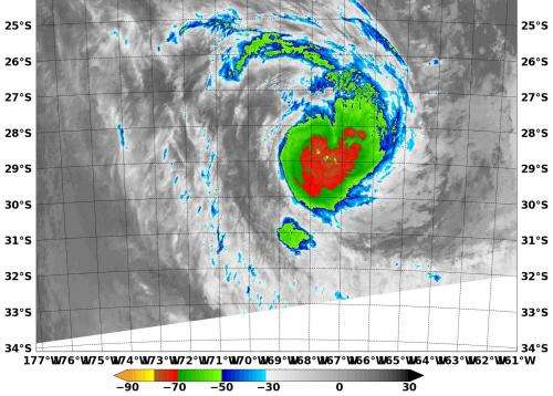
NASA sees strong thunderstorms around Tropical Cyclone Kofi

NASA's Terra satellite passed over Tropical Cyclone Kofi in the Southwestern Pacific Ocean and captured an infrared image of the storm revealing powerful thunderstorms around center of circulation.
The Moderate Resolution Imaging Spectroradiometer or MODIS instrument that flies aboard NASA's Terra satellite captured an infrared image on March 3 at 09:55 UTC/4:55 a.m. EST. Cloud top temperatures were near -80C/-112F indicating very strong thunderstorms around the center.
At 0900 UTC/4 a.m. EST Tropical Storm Kofi had maximum sustained winds near 45 knots51.7 mph/83.3 kph. It was centered over open water near 27.6 south and 169.1 west, about 803 nautical miles/924 mph/1,487 km south of Pago Pago, American Samoa. Kofi was moving to the east-southeast at 20 knots/23 mph/37 kph. The Joint Typhoon Warning Center expects Kofi to continue moving southeast and is no threat to land.
Kofi is already undergoing extra-tropical transitioning, a process that should be complete by March 4.
Provided by NASA's Goddard Space Flight Center


