March 24, 2014 report
Computer model shows continents sometimes push others out of the way (w/ video)

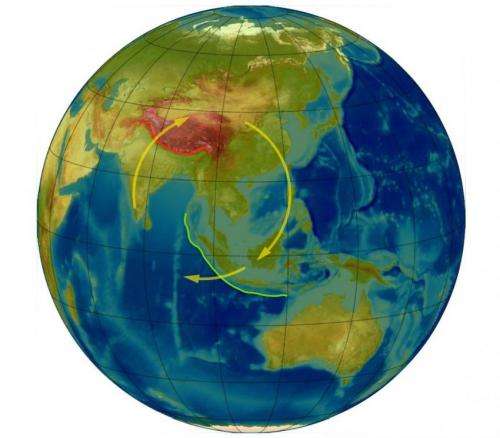
(Phys.org) —A team of researchers at the University of Melbourne in Australia has created a computer model that accurately predicts some aspects of mountain formation in early Australian history and has now described a new theory suggesting why the Himalayas continue to grow. In their paper, published in the journal Nature, the team describes how their model is challenging previously held theories regarding what happens when continental plates collide.
The planet is still evolving, despite what our eyes tell us. The continents, for example, are all moving—some of them are even crashing into one another causing earthquakes and mountain formation. The surface of the Earth is divided into several pieces known as plates, each of which is still moving in one direction or another. When such plates run into others, one of two things can happen: one can slip beneath the other, or the two can smash together causing great upheaval which results in the formation of mountains. Scientists studying plate movement have been trying to predict what will happen when collisions occur—whether there will be subduction or mountain formation, and if it's the latter, what sorts of features the mountains will have. In this new effort, the researchers in Australia appear to have taken a step forward in doing just that.
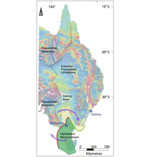
To gain a better understanding of exactly what occurs when plates collide, the researchers built a computer model that used data and information compiled from prior research. They then added a new idea, in which continents can be squeezed upwards as other parts are pushed aside. They then set the model's clock back in time to see if it could predict what we see around us today. Remarkably, in the case of one ancient small plate running into Australia, the model proved surprisingly accurate—creating realistic renditions of a mountain range that currently exists in eastern Australia—it even revealed how several formations could have come to exist that had defied earlier explanation.

The new computer model can't prove what it illustrates but does appear to be a new step forward in explaining how our planet came to look like it does to today, and perhaps what it will look like in the future.
More information: Dynamics of continental accretion, Nature (2014) doi:10.1038/nature13033
Abstract
Subduction zones become congested when they try to consume buoyant, exotic crust. The accretionary mountain belts (orogens) that form at these convergent plate margins have been the principal sites of lateral continental growth through Earth's history. Modern examples of accretionary margins are the North American Cordilleras and southwest Pacific subduction zones. The geologic record contains abundant accretionary orogens, such as the Tasmanides1, along the eastern margin of the supercontinent Gondwana, and the Altaïdes, which formed on the southern margin of Laurasia2. In modern and ancient examples of long-lived accretionary orogens, the overriding plate is subjected to episodes of crustal extension and back-arc basin development, often related to subduction rollback3 and transient episodes of orogenesis and crustal shortening4, 5, 6, 7, coincident with accretion of exotic crust. Here we present three-dimensional dynamic models that show how accretionary margins evolve from the initial collision, through a period of plate margin instability, to re-establishment of a stable convergent margin. The models illustrate how significant curvature of the orogenic system develops, as well as the mechanism for tectonic escape of the back-arc region. The complexity of the morphology and the evolution of the system are caused by lateral rollback of a tightly arcuate trench migrating parallel to the plate boundary and orthogonally to the convergence direction. We find geological and geophysical evidence for this process in the Tasmanides of eastern Australia, and infer that this is a recurrent and global phenomenon.
Journal information: Nature
© 2014 Phys.org


