First measurement flight: Research aircraft HALO explores trade wind clouds

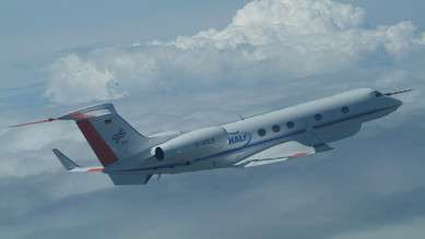
Which climate effects do clouds have? Under what conditions do they warm or cool the atmosphere? Today, after more than five years of preparation, the specially equipped research aircraft HALO (High Altitude and Long Range Research Aircraft) takes off for its first measurement flight in atmospheric research. Prof. Bjorn Stevens and Dr. Lutz Hirsch from the Max Planck Institute for Meteorology (MPI-M) leave Oberpfaffenhofen in Germany for a ten-hour flight to Barbados. They will operate numerous measuring instruments on board HALO on behalf of the German atmospheric research: "A day we have eagerly awaited", says Stevens. "It is the first major mission to exploit the novel capabilities of HALO to measure vertical profiles of all components of atmospheric water – like vapor, liquid and ice, in both cloud and precipitation forms, as well as the aerosol particles upon which cloud droplets form - from a high altitude. A new era of airborne atmospheric research." The aircraft, equipped with a large amount of advanced technology, is an initiative by German climate and environmental research institutions (see below) and is operated by the German Aerospace Center (DLR).
The flight is part of the NARVAL project (Next-generation Aircraft Remote-Sensing for Validation Studies) and will provide the scientists with more detailed information on the constitution of tropical clouds (Fig. 1). The transatlantic flights from Oberpfaffenhofen to Barbados will complement the stationary measurements of the cloud observatory on Barbados. The collected data will contribute to a better understanding of cloud and precipitation processes and will help to reduce uncertainties in climate models.
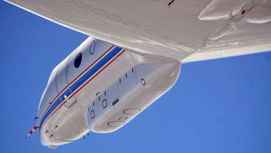
Remote sensing instruments, located in the "Belly Pod" underneath the aircraft´s hull, will detect vertical profiles of temperature and humidity and the distribution of droplets and aerosols (Fig. 2). Additionally, so-called dropsondes will be released during the flight. These radiosondes usually ascend from Earth with the help of a weather balloon and perform measurements on their way through the atmosphere. This time, they will be dropped by parachute and will glide back to the ground.

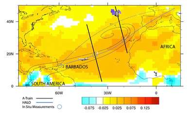
The first measurement flight is a joint project of the MPI-M with the Meteorological Institute of the University Hamburg, DLR, Universities of Cologne, Leipzig and Heidelberg and the Forschungszentrum Jülich. It will take the scientists on a long-haul flight to Barbados, where the MPI-M cloud observatory is located, and back. Ideally, comparison measurements with the satellite CloudSat will be performed during the flights. The satellite measures the Atlantic clouds in trajectories crosswise to the flight route. Short flights of HALO in parallel with these satellite trajectories make it possible to verify the satellite´s measurements (Fig. 3): the aircraft flies at a lower altitude than the satellite and can therefore detect the clouds much more accurate.
In total, the air route Oberpfaffenhofen – Barbados and back should be flown three times in December 2013 ("NARVAL South"). During the second flight, a local flight from Barbados eastward through the trade wind clouds is planned. The aim is to detect clouds that are directly heading for the Barbados cloud observatory and to compare them to the land-based cloud observatory data.

The second part of the mission will be carried out under the direction of the University Hamburg in January ("NARVAL North"). HALO will be based on Iceland to examine the backsides of fronts over the North Atlantic. The amount of precipitation on the backsides of fronts is a controversial topic in science because satellite observations and model calculations provide different results. "Measured values are missing because ships do not sail in these typical storm zones" says principal investigator Prof. Felix Ament from the Center for Earth System Research and Sustainability (CEN), University of Hamburg. "A successful HALO mission could provide important facts and eliminate a 'blank spot' on the map of science."
More information: www.halo.dlr.de/
Provided by Max Planck Society


