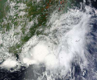
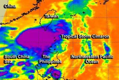
NASA's 2 views of Tropical Storm Cimaron making landfall in China

Looking at the extent of a tropical cyclone's clouds from space doesn't tell you all you need to know about a storm, so satellites use infrared, microwave and multi-spectral imagery to look "under the hood." Two NASA satellites provided an outside and inside look at Tropical Storm Cimaron as it was starting to make landfall in China.
The Atmospheric Infrared Sounder or AIRS instrument that flies aboard NASA's Aqua satellite captured an infrared image of Tropical Storm Cimaron on July 17 at 17:29 UTC (1:29 p.m. EDT). Infrared data helps determine temperature, such as the cloud top and sea surface temperatures. AIRS data revealed that Cimaron's strongest storms and heaviest rains were east of the center and had cloud top temperatures near -63F/-52C and stretched from northern Luzon, Philippines to the southern tip of Taiwan at the time Aqua passed overhead.
The Moderate Resolution Imaging Spectroradiometer or MODIS instrument that flies aboard NASA's Terra satellite captured a visible image of Tropical Storm Cimaron over Taiwan and China on July 18 at 02:55 UTC (7/17 at 10:55 p.m. EDT). Cimaron's western edge had already reached the coast of southeastern China (where it is expected to make landfall).Most of the heaviest thunderstorms at the time Terra passed overhead were over the South China Sea. The visible MODIS image also showed that Cimaron appears more disorganized than it was the day before. There appear to be four areas of strong thunderstorms, fragmented around the center of circulation. The strongest storms were in Cimaron's eastern quadrant.
On July 17 at 1500 UTC (11 a.m. EDT), Cimaron's maximum sustained winds dropped to 35 knots (40 mph/64.8 kph). Cimaron's center was just off the coast of southeastern China, and its center was poised for landfall. The storm's center was located near 24.0 north latitude and 116.9 east longitude, about 176 nautical miles (202 miles/ 326 km) east-northeast of Hong Kong. Cimaron was moving to the northwest at 6 knots (7 mph/11.1 kph).

At that time, radar from Shantou, China showed shallow rainbands wrapping into a well-defined center. At that time, Shantou was just 15 nautical miles (17.2 miles/27.7 km) west-southwest of Cimaron's center of circulation.
The Joint Typhoon Warning Center issued their final bulletin on the storm, and noted that Cimaron is expected to quickly dissipate inland.
Provided by NASA's Goddard Space Flight Center


