NASA spots heavy rainfall in Tropical Depression 26W threatening Micronesia

The twenty-sixth tropical cyclone of the western North Pacific Ocean season formed and has some areas of heavy rain, according to data from NASA's TRMM satellite. Tropical Depression 26W is threatening islands within Micronesia and warnings and watches are currently in effect.
Micronesia is a region in the western North Pacific Ocean made up of thousands of small islands. West of the region is the Philippines, while Indonesia is located to the southwest.
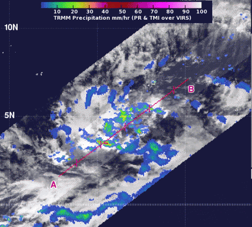
NASA's Tropical Rainfall Measuring Mission (TRMM) satellite passed over Tropical Depression 26W on Nov. 26 at 0526 UTC (12:26 a.m. EST). The imagery showed that the depression's low-level center was large, and it had some fragmented convective bands of thunderstorms wrapping around it that contained heavy rain, falling at 2 inches/50 mm per hour. TRMM data also revealed tall convective towering thunderstorms about 15 kilometers (9.3 miles) high. According to previous NASA research, those "hot towers" usually signify that a tropical cyclone will intensify.
According to NOAA's National Weather Service in Tiyan, Guam, a tropical storm warning remains in effect for Nukuoro in Pohnpei State and Lukunor in Chuuk State. A tropical storm watch remains in effect for Losap and for Chuuk Lagoon Islands in Chuuk State.
A tropical storm warning means tropical storm conditions, including damaging winds of 39 to 73 mph are expected within 24 hours while a tropical storm watch means that tropical storm conditions are possible within 48 hours.
At 1500 UTC (10 a.m. EST) on Nov. 26, 2012, Tropical Depression 26W (TD26W) was centered near 4.8 degrees north latitude and 155.1 degrees east longitude. That put TD26W's center about 65 miles north of Nukuoro, 95 miles southeast of Lukunor, and 215 miles southeast of Losap. The National Weather Service noted that TD26W is moving west-northwest at 7 mph and is expected to move in a more westerly direction and slightly speed up over the next day. Maximum sustained winds are near 35 mph, and could become a tropical storm later today, Nov. 26.
Forecasters at the Joint Typhoon Warning Center expect Tropical Depression 26W to track to the west-northwest over the next several days and strengthen to typhoon status as it tracks through the warm waters of the Philippine Sea. TD26W is forecast to pass just south of Chuuk and affect Yap and Palau by the weekend of Dec. 1 and Dec. 2.
Provided by NASA's Goddard Space Flight Center


