NASA sees more rain for the Philippines from Tropical Storm Kai-Tak

An intensifying Tropical storm called Kai-Tak (locally known as Helen) is causing more rain in the Philippines as it passes over northern Luzon. The Philippines have had a very wet month with the capital of Manila experiencing massive flooding earlier this month. NASA's TRMM satellite identified where the heavy rain was falling.
Kai-tak has caused another day of warnings in the Philippines. On August 14, Public storm warning signal #1 is in effect for these provinces in Luzon: La Union, Nueva Ecija, Pangasinan, Rest of Aurora, and Tarlac.
In addition, Public storm warning signal #2 has been posted for these Luzon provinces: the Abra and Batanes Group of Islands, Apayao, Benguet; Cagayan (including Calayan and Babuyan Group of Island), Ifugao, Ilocos South and North, Isabela, Kalinga, Mt. Province, Northern Aurora, Nueva Vizcaya, and Quirino.
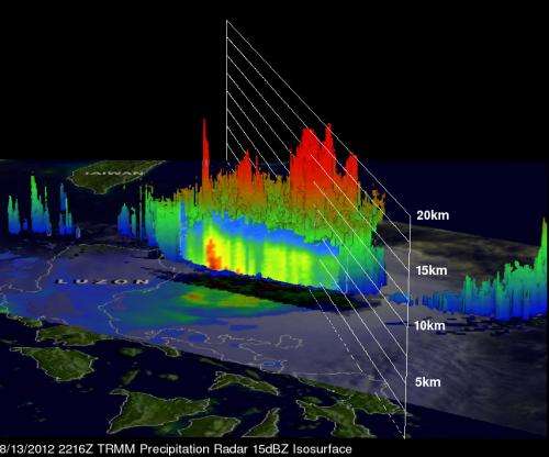
The Tropical Rainfall Measuring Mission (TRMM) satellite flew over Kai-tak on August 13, 2012 at 2216 UTC 4:16 p.m. EDT). TRMM's Microwave Imager (TMI) and Precipitation Radar (PR) data showed that the tropical storm was dropping extreme amounts of rainfall. TRMM PR revealed that the most intense rainfall of over 100mm/hr. (~3.9 inches) was east of the Philippines over the open waters of the Pacific Ocean. Some light to moderate rainfall from Kai-tak was shown falling on the island of Luzon.
TRMM's Precipitation Radar (PR) data were used in a 3-D image to show the vertical scale of the numerous powerful storms near Kai-tak's center. Some convective storms were reaching heights of about 15km (~9.3 miles).
Tropical storm Kai-tak had maximum sustained winds near 50 knots (57.5 mph/92.6 kmh). It was located about 220 nautical miles (253 miles/407 km) northeast of Manila, Philippines, near 17.4 North latitude and 123.1 East longitude. Kai-tak was moving to the southwest at 10 knots (11.5 mph/18.5 kmh) and is expected to turn to the west-northwest.
Satellite data from August 14 has shown that Kai-tak's low-level center has become more organized. The Atmospheric Infrared Sounder (AIRS) instrument that flies onboard NASA's Aqua satellite showed cooler cloud top temperatures (a sign of more uplift and strength in the storm).
Kai-tak is taking a track across northern Luzon and is expected to move south of Taiwan before making landfall in China.
Provided by NASA's Goddard Space Flight Center


