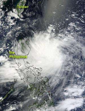
NASA sees Tropical Storm Kai-tak brushing the Philippines

NASA's Terra satellite captured an image of Tropical Storm Kai-tak affecting the northern Philippines on August 13 as the storm heads toward China for a final landfall.
Warnings are already in effect in part of the Philippines. Tropical storm Kai-tak is the fourteenth tropical cyclone of the western North Pacific season. On August 13 at 11 a.m. EDT, Kai-tak had maximum sustained winds near 40 knots (46 mph/74 kmh). It was located approximately 290 nautical miles (334 miles/ 537 km) east-Northeast of Manila, Philippines, has tracked west-southwestward at 11 knots (12.6 mph/20.3 kmh). The storm is called "Helen" in the Philippines, and its close proximity has caused the issuance of warnings.
Public storm warning signal #1 is in effect for the Luzon provinces: Apayao, Cagayan, Babuyan, Quirino, Aurora, Isabela, Kalinga, and the Batanes and Calayan group of islands. Public Signal #1 means winds between 28-37 mph (45-60 kmh) can be expected.
Public Storm Signal 2 is in effect for Isabela and Cagayan, where winds between 37-62 mph (61-100 kmh) can be expected. The Philippine Atmospheric Geophysical and Astronomical Services Adminstration, known as PAGASA, caution residents living in low lying and mountainous areas that flash flooding and mudslides are possible from the heavy rainfall. In addition, residents living along the coasts are being cautioned against large waves or storm surges.
The Moderate Resolution Imaging Spectroradiometer (MODIS) instrument onboard NASA's Terra satellite captured an image of Tropical Storm Kai-tak, located just off the east coast of the Philippines on August 13 at 0230 UTC (Aug. 12 at 10:30 p.m. EDT). Satellite imagery showed that the convection (rising air that forms the thunderstorms that make up the tropical storm) have strengthened around the center of the storm. The MODIS image was created at NASA's Goddard Space Flight Center in Greenbelt, Md. by the MODIS Rapid Response Team.
Kai-tak is moving along the southern edge of a subtropical ridge, which is an elongated area of high pressure. Kai-tak will move northwestward and slowly intensify, passing through the Luzon Strait, while its center stays at sea, north of Luzon, the Philippines.Kai-tak is expected to make landfall north of Hong Kong on August 16. Although forecasters at the Joint Typhoon Warning Center expect Kai-tak to strengthen, it is expected to weaken before making landfall because of cooling ocean heat content and wind shear.
Provided by NASA's Goddard Space Flight Center


