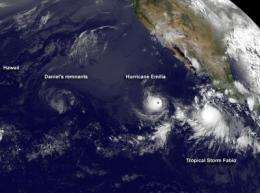
Satellite sees remnants of former Tropical Storm Daniel

Daniel is no longer a tropical storm, and has weakened to a remnant low pressure system, but its circulation is still visible on satellite imagery today, July 12 as it moves south of Hawaii.
A visible image from NOAA's GOES-15 satellite on July 12, 2012 shows the circulation of Daniel's remnants heading toward Hawaii, followed by Hurricane Emilia to the east, and further east is Tropical Storm Fabio. Daniel's remnants appear as a ghost-like swirl of clouds in comparison to the organized and bright white clouds in powerful Hurricane Emilia.
The image was created by the NASA GOES Project, located at NASA Goddard Space Flight Center in Greenbelt, Md. NASA's GOES Project uses data from the NOAA satellite and creates images and animations. At that time it was still about 800 miles east-southeast of Hilo, Hawaii.
Daniel's remnants are forecast to pass to the south of Hawaii and will not affect the state.
Provided by NASA's Goddard Space Flight Center


