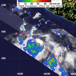
NASA sees hot towers as Tropical Storm Fabio's trigger

NASA research has indicated whenever "Hot Towering" thunderstorms are spotted within a tropical cyclone, it is more likely to strengthen. NASA's TRMM satellite saw hot towers within newborn Tropical Depression 06E when it passed overhead early on July 12 and it later became Tropical Storm Fabio.
Tropical Depression 06E (TD06E) was seen by the TRMM satellite on July 12, 2012 at 0632 UTC (2:32 a.m. EDT). TD06E had mostly light to moderate rainfall where rain was falling between 20 and 40 millimeters (.78 to 1.57 inches) per hour. However, some heavy rainfall (red) and hot towering clouds were seen around the center of circulation. Data was used to create a snapshot of TD06E's rainfall by Hal Pierce of the TRMM team at NASA's Goddard Space Flight Center in Greenbelt, Md.
A "hot tower" is a tall cumulonimbus cloud that reaches at least to the top of the troposphere, the lowest layer of the atmosphere. It extends approximately nine miles (14.5 km) high in the tropics. The hot tower in Tropical Depression 06E was over 9.3 miles (15 km) high. These towers are called "hot" because they rise to such altitude due to the large amount of latent heat. Water vapor releases this latent heat as it condenses into liquid.
Research by Owen Kelley and John Stout of George Mason University and NASA's Goddard Space Flight Center, Greenbelt, Md., shows that a tropical cyclone with a hot tower in its eyewall was twice as likely to intensify within six or more hours than a cyclone that lacked a tower.
On July 12, Tropical Depression 06E was "born" with maximum sustained winds near 35 mph (55 kmh) at 5 a.m. EDT (0900 UTC). Less than nine hours later, TD06E became Tropical Storm Fabio, with maximum sustained winds up to 40 mph (65 kmh). It was located about 425 miles (680 km) south-southwest of Manzanillo, Mexico near 13.6 north latitude and 107.2 west longitude. Fabio was moving to the west near 9 mph (15 kmh). The National Hurricane Center noted Fabio is expected to continue strengthening today.
Provided by NASA's Goddard Space Flight Center


