Managing floods on nature's terms
Mathematical models describing the interaction between water flow, vegetation and sediments in river basins are being developed at Aalto University. The hydraulic models will be used to create a basis for natural, environmentally friendly flood management.
Floods have traditionally been prevented by clearing river beds and building floodbanks. However, as environmental awareness has increased, people are now more prone to criticise major construction operations.
Therefore, natural ways for managing floods are needed in order for the vegetation and nature values of riversides to be maintained. The EU directive on the assessment and management of flood risks that entered into force in 2007 also encourages this approach.
"Floodbanks can no longer be built just in case. Authorities and planners must be able to prove that the measures used are necessary," says Docent Juha Järvelä from the Department of Civil and Environmental Engineering.
Leaves resist flow
In addition to researchers from Aalto University, researchers from the BOKU University of Natural Resources and Life Sciences in Vienna will also participate in the four-year project funded by the Academy of Finland. The Austrian researchers will bring biological expertise to the project.
In addition to flood management, the researchers are interested in nutrient and sediment discharges in river environments. Vegetation prevents erosion and retains sediments and nutrients.

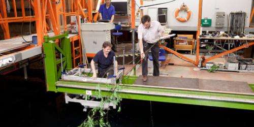
During the research project, trees that typically grow by riversides, birches, alders and willows, will be towed in water at different speeds. The drag caused by the trees will be measured and the deformation the trees go through in flowing water will be videoed using underwater video cameras.
In addition to drag, the researchers will determine the leaf area and structure of each tree using both laser scanning and an electromagnetic method. As a result of the measurements, the group will be able to create millimetre-level 3D structural models of the trees.
By combining the data, the researchers will be able to determine the drag caused by different tree species and their leaves when they end up in water. The project is exceptional even on an international scale since similar experimental studies linking hydraulic theory to biological expertise and the most recent measurement methods have not been performed before.
It is already a known fact that the flow resistance of trees is significantly greater when there are leaves in them than when they have dropped their leaves. The phenomenon was visible in summer 2004 when continuous rains caused flooding in Southern Finland. Vegetation slowed down water flow so that water levels rose much more than during spring floods although the amount of rainfall was significantly smaller than the amount of water produced from melting snow in the spring.
Towards remote sensing
The current research project will create mathematical models that are significantly more accurate and usable than previous models used in the estimation of floods.
The project models actual trees and their leaves unlike previous modelling projects that have been based on small-scale experiments performed on rigid, cylinder-like objects. The modelling process is demanding because trees have a very complex structure and because they bend and their branches move closer to the trunk in flowing water.
Although the project represents basic research, it is also expected to serve practical work relatively soon.

"It will probably be possible to put the mathematical models that are now being developed into practice in the next couple of years. A lot depends on how eager planners are to adopt new methods," Järvelä explains.
He envisages a development path where the mathematical models being created in the current project would be combined with remote sensing methods implemented using satellites or aeroplanes.
Remote sensing can be used to effortlessly measure the leaf area index of a river basin and create GIS data describing the properties of the vegetation in the area. When the hydraulic models are combined with this information, it will be possible to assess how leaving vegetation untouched or clearing an area from vegetation will affect the water flow and flood susceptibility of a river.
Experiments inside and outdoors
The research project led by Järvelä employs two doctoral candidates from Aalto University, one doctoral candidate from the BOKU University of Natural Resources and Life Sciences in Vienna and several foreign exchange students and trainees.
The towing basin and flow flume of the School of Engineering provide an excellent environment for large-scale experiments. The interaction between vegetation, sediments and flow is also being studied in the Ritobäcken brook in Sipoo. An automatic sampler and measurement and weather stations have been installed by the brook.
Provided by Aalto University


