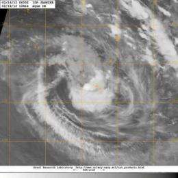
NASA sees Tropical Cyclone Jasmine near Tonga

Tropical Cyclone Jasmine is still lingering near the island nation of Tonga in the South Pacific and was captured in an infrared image from NASA's Aqua satellite. Jasmine is bringing gusty winds and heavy rainfall to some of Tonga's islands.
When Aqua flew over Cyclone Jasmine on February 14, 2012 at 1241 UTC (7:41 a.m.), the Moderate Resolution Imaging Spectroradiometer (MODIS) instrument captured an infrared image of its clouds. The image showed the strongest thunderstorms and heaviest rainfall appear to be on the northeastern quadrant of the storm.
A gale warning is in force for the Tongatapu group of islands. The islands are experiencing gusty winds and heavy rainfall as Jasmine creeps away slowly.
On February 14 at 0900 UTC, the Joint Typhoon Warning Center noted that Jasmine's center was just 25 nautical miles (28.7 miles/46.3 km) west-southwest of Tonga, near 21.3 South and 175.6 West. It was bringing gusty winds and rainfall to Tonga today, and is expected to start moving away to the south at 5 knots (~6 mph/~9 kph). Jasmine's maximum sustained winds were near 45 knots (~52 mph/~83 kph) but it is expected to strengthen a little as it moves away through warmer waters.
Provided by NASA's Goddard Space Flight Center


