NASA satellites see TD5's remnants still soaking Louisiana and Mississippi

Tropical Depression Five's remnants continue to linger over Louisiana and Mississippi, and NASA satellite data continues to capture its cloud temperatures and extent. The slow moving remnants and an associated tropical air mass are expected to creep across the Louisiana and Mississippi and into Arkansas for the next couple of days.
Tropical Depression Five's (TD5) remnants remain over the lower Mississippi valley today and are slowly drifting northeast. Yesterday, NASA satellite imagery observed the bulk of TD5's precipitation just south of Louisiana, over the Gulf of Mexico. Today, August 18, that precipitation has moved north and is drenching east-central Louisiana and western Mississippi.
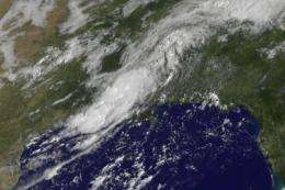
The Geostationary Operational Environmental Satellite called GOES-13 captured a visible image of TD5's remnant clouds on August 18 at 14:31 UTC (10:31 a.m. EDT). The satellite image showed the remnants of TD5 stretched from Louisiana northeast into Mississippi. The high-resolution image even showed some higher thunderstorms embedded in the cloud cover, likely indicating areas of heavier rainfall. The GOES series of satellites are operated by NOAA, and the NASA GOES Project at NASA's Goddard Space Flight Center in Greenbelt, Md. creates images and animations of GOES satellite imagery.
National Weather Service forecasters noted that "the low is weak and lift has been too small to generate much in the way of rainfall overnight...but with precipitable water observed to be 2.7 inches at Jackson, Mississippi in this tropical air mass, expect convection (rapidly rising air that forms thunderstorms) to become widespread after a little [daytime] heating." That means that the showers and thunderstorms will "power up" from the daytime heating and the heaviest precipitation will fall during that time then diminish when the sun sets.

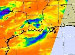
The Atmospheric Infrared Sounder (AIRS) instrument on NASA's Aqua satellite captured an infrared view of TD5's remnant clouds and showers over Louisiana and the north central Gulf of Mexico on August 18 at 08:23 UTC (4:23 a.m. EDT), and didn't show any extremely high, very cold thunderstorm cloud tops during the early morning hours, which correlates with lighter precipitation during night-time periods. During the daytime when the heat of the sun powers convection (rapidly rising air that condenses and forms clouds and thunderstorms), cloud tops would likely be higher and colder (and thunderstorms more potent) on AIRS infrared imagery.
A flash flood watch was issued for today and this evening for much of central Mississippi and northeastern Louisiana due to the risk for very heavy rainfall associated with the remnants of tropical depression five. Two to three inches of rainfall and locally higher amounts of greater than five inches will be possible. Live National Weather Service radar from Brandon/Jackson, Mississippi: http://radar.weather.gov/radar.php?rid=DGX&product=NCR&overlay=11101111&loop=yes
Louisiana, Mississippi and Arkansas can expect a slow and continued soaking as TD5's remnants continue to creep northeast.
Provided by NASA's Goddard Space Flight Center


