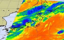
NASA's Aqua Satellite sees Dianmu enter the Sea of Japan

NASA captured infrared imagery of Dianmu entering the Sea of Japan today, August 11. Tropical Storm Dianmu made a quick track over South Korea and has already emerged in the Sea of Japan. She's on track for crossing northern Japan and then moving into the North Western Pacific Ocean.
The Atmospheric Infrared Sounder (AIRS) instrument onboard NASA's Aqua satellite captured an infrared image of Dianmu on August 11 at 4:29 UTC (12:29 a.m. EDT). That showed her center exiting South Korea and entering the Sea of Japan. The strongest areas of convection (rapidly rising air that form the thunderstorms that power the tropical storm) appeared around Dianmu's center. The next AIRS image on 16:29 UTC (12:29 p.m. EDT) showed Dianmu as an elongated system with most of the convection to the eastern part of the storm.
At 1500 UTC (11 a.m. EDT) on August 11, Dianmu had maximum sustained winds near 46 mph (40 knots). It was 500 nautical miles west-southwest of Misawa, Japan, and moving east-northeast near 20 mph. it is generating 15-foot high waves in the Sea of Japan today.
Dianmu is transitioning into an extra-tropical storm as it encounters increasing vertical wind shear and cooler sea surface temperatures. Those are two factors that weaken a tropical cyclone. Dianmu is expected to make landfall over north Honshu, Japan on August 12.
Provided by NASA's Goddard Space Flight Center


