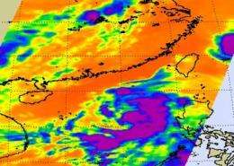
NASA infrared image of Tropical Storm Chanthu shows convection missing on west side

The fourth tropical depression of the western Pacific Ocean strengthened into a tropical storm and was named Chanthu today. Infrared imagery from the Atmospheric Infrared Sounder (AIRS) instrument that flies aboard NASA's Aqua satellite captured areas of strong convection from northeast to southwest, but convection isn't showing on the storm's west side.
At 1500 UTC (11 a.m. EDT) on July 20, Tropical Storm Chanthu's maximum sustained winds were near 46 mph (40 knots). Chantu was located about 240 nautical miles south of Hong Kong, China, near 18.6 North and 114.3 East. It was moving west-northwestward near 8 mph (7 knots), and is forecast to make a landfall south of Hong Kong by 1800 UTC (3 p.m. EDT) tomorrow, July 21 or 3 a.m. local time/Hong Kong on July 22.
The Hong Kong Observatory has posted Standby Signal, No. 1. That means that a tropical cyclone now centred within about (~500 miles) 800 kilometers of Hong Kong.
Infrared imagery from NASA's AIRS instrument on July 19 at 18:05 UTC (2:05 p.m. EDT) showed strong convection (rapidly rising air that forms the thunderstorms that power a tropical cyclone) from northeast to southwest. By July 20, convection had become fragmented, which indicated to forecasters at the Joint Typhoon Warning Center (JTWC) that any further strengthening will be limited.
The JTWC forecast notes that although the eastern side of the storm is showing convection, the western side is lacking it. This morning's JTWC report noted "Convection has been somewhat dampened on the western periphery of the circulation due to an upper level trough (elongated area of low pressure) positioned over the extreme-western South China Sea."
Two factors will play into the strength of Tropical Storm Chanthu over the next two days as it nears landfall: dry air and increased wind shear. Both of those factors will help weaken Chantu on its journey to a landfall in China.
Provided by NASA's Goddard Space Flight Center


