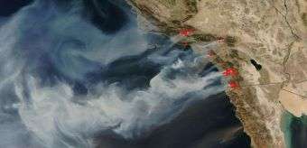
New Image of Raging California Wildfires

NASA satellites continue to capture remarkable new images of the wildfires raging in Southern California. At least 14 massive fires are reported to have scorched about 425 square miles from north of Los Angeles to southeast of San Diego.
These latest images, captured by NASA satellites on the afternoon of October 22, show the thick, billowing smoke coming off the numerous large fires and spreading over the Pacific Ocean. Fire activity is outlined in red.
Dry, drought-stricken vegetation and Santa Ana winds, which can reach hurricane speeds, have contributed to the devastating effect of these blazes. The National Interagency Fire Center reports that the Santa Ana winds are expected to continue through Wednesday.
According to news reports, almost 700 homes have been destroyed and hundreds of thousands of residents have been forced to evacuate.
Today, President Bush issued an emergency declaration for seven California counties, ordering federal disaster relief to the area.
Source: NASA


