NASA adds up Tropical Storm Mekkhala's drenching rainfall in the Philippines

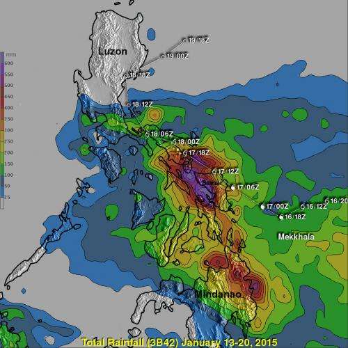
NASA/JAXA's Global Precipitation Measurement (GPM) mission can measure rainfall rates from space and its data combined with other satellite data provides are used to calculate rainfall totals. After Tropical Storm Mekkhala drenched the eastern Philippines, a rainfall map was created showing almost two feet of rainfall in an isolated area.
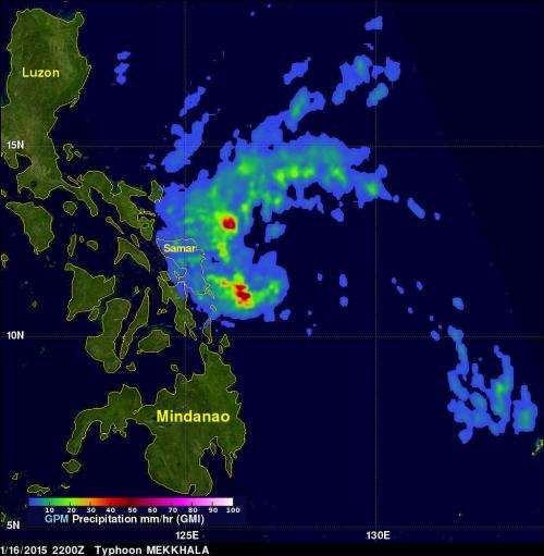
On January 16, 2015 Tropical Storm Mekkhala became the first western Pacific typhoon of the year just before hitting the eastern Philippines. The Microwave Imager (GMI) aboard the GPM mission's core satellite found rain falling at a rate of over 70.7 mm (about 2.8 inches) per hour in storms southwest of the Mekkhala's eye on Jan. 16 at 2200 UTC. That measurement was made only about four hours after Mekkhala was upgraded to a typhoon.
Typhoon Mekkhala added to rainfall already received from other storms over the eastern Philippines during the week of January 13-20, 2015. All of that rainfall was analyzed using near real time merged satellite data. The analysis found an area of maximum rainfall centered just west of Samar where extreme rainfall totals were greater than 600 mm (23.6 inches).The analysis was conducted at NASA's Goddard Space Flight Center in Greenbelt, Maryland.
Much of the heavy rainfall from Mekkhala fell over the same area where Super Typhoon Haiyan devastated the Philippines in October 2013. The same area was also more recently soaked by deadly typhoon Hagupit and Tropical Storm Jangmi in December 2014.
Mekkhala moved into the Philippine Sea east of Luzon and dissipated on January 21.

Provided by NASA's Goddard Space Flight Center


