A new global wetlands map
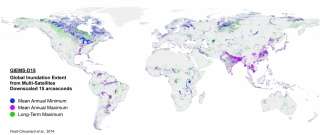
A new global map of the world's wetlands has been produced by an international research team led by former master's student Etienne Fluet-Chouinard and Prof. Bernhard Lehner of McGill's Department of Geography. In a paper published in the journal Remote Sensing of Environment, the researchers present a method producing a map in finer detail than previously available.
This is made possible by using topographic information combined with satellite measurements generated by French collaborators from the Laboratoire d'Etudes du Rayonnement et de la Matière en Astrophysique et Atmosphères and Estellus.
The map represents a long-term baseline of the world's wetland areas, including areas of artificial inundation and some waterlogged soils, based on measurements made between 1993 and 2004. "This map represents a great asset for scientists to study large inundation patterns and wetland ecosystems at the global scale," says Fluet-Chouinard, now a PhD Student at the University of Wisconsin-Madison's Center for Limnology.
More information
Fluet-Chouinard, E., Lehner, B., Rebelo, L.M., Papa, F., Hamilton, S.K., (2015) "Development of a global inundation map at high spatial resolution from topographic downscaling of coarse-scale remote sensing data," Remote Sensing of Environment, 158: 348-361. dx.doi.org/10.1016/j.rse.2014.10.015
A PDF version of the map is available online: www.mcgill.ca/channels/sites/m … wetlands_map_pdf.pdf
Provided by McGill University


