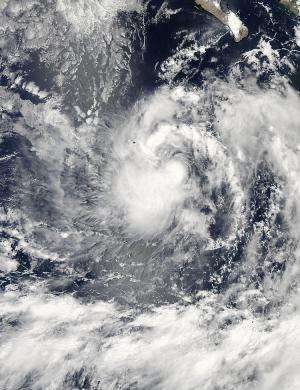
NASA sees fragmented thunderstorm bands wrapped around Tropical Storm Karina

Although Tropical Storm Karina is still strengthening in the Eastern Pacific Ocean NASA's Aqua satellite revealed a large band of fragmented thunderstorms wrapping into its center from the north.
On August 13 at 21:00 UTC (5 p.m. EDT), the MODIS or Moderate Resolution Imaging Spectroradiometer instrument aboard NASA's Aqua satellite captured a visible image of Tropical Storm Karina off the west coast of Mexico. The image showed a concentration of strong thunderstorms around the center of circulation while the band of thunderstorms to the north appeared broken. The strongest and largest area of precipitation appeared on the storm's southwestern side.
At 5 a.m. EDT (2 a.m. PDT/0900 UTC) on Thursday, August 14, the center of Tropical Storm Karina was located near latitude 17.4 north and longitude 115.2 west. That's about 510 miles (825 km) south of the southern tip of Baja California, Mexico. Karina was moving toward the west near 14 mph. (22 kph). Maximum sustained winds have increased to near 60 mph (95 kph) and the National Hurricane Center expects the storm to continue strengthening.
The NHC expects Karina to become a hurricane late on August 14 as it continues in a westerly direction through the Eastern Pacific Ocean.
Provided by NASA's Goddard Space Flight Center


