A train of five tropical cyclones in the Central and Eastern Pacific

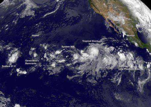
A train of developing tropical low pressure areas stretch from the Eastern Pacific Ocean into the Central Pacific and they were captured in an image from NOAA's GOES-West satellite on August 1. The train of five tropical lows include the remnants of Tropical Storm Genevieve and newly developed Tropical Storm Iselle.
NOAA's GOES-West satellite captured an image of the Pacific Ocean on August 1 at 1200 UTC (8 a.m. EDT) that showed post-tropical cyclone Genevieve's remnants between three other systems. The GOES-West image shows the train of storms with a well-developed Iselle near the end of the train.
NOAA manages the GOES-West and GOES-East satellites. Data from the satellites are used to create images and animations from NASA/NOAA's GOES Project at NASA's Goddard Space Flight Center in Greenbelt, Maryland.
System 91C
The western-most tropical low pressure area lies to the west of Genevieve's remnants. That low is designated as System 91C. At 0600 UTC (2 a.m. EDT), the center of System 91C was located near 12.0 north latitude and 167.3 west longitude, about 850 miles southwest of Honolulu, Hawaii. 91C has a low chance of developing into a tropical depression over the next couple of days.
East of System 91C lie Genevieve's remnants. NOAA's Central Pacific Hurricane Center (CPHC) issued the final warning on Post-tropical cyclone Genevieve on July 31 at 1500 UTC (11 a.m. EDT). At that time it was centered near 13.0 north latitude and 151.1 west longitude, about 1,255 miles east of Johnston Island. It was moving west.
Genevieve's Remnants
At 8 a.m. EDT on August 1, Genevieve's remnant low center was located about 500 miles south-southeast of Hilo, Hawaii. CPHC noted the atmospheric conditions are only marginally favorable for its redevelopment over the next few days as it moves westward near 10 mph.
System 96E
Continuing east, System 96E is tracking behind Genevieve's remnants. System 96E is another developing low pressure area with a minimal chance for becoming a tropical depression. The CPHC gives System 96E a 10 percent chance of development over the next two days. It is located in the Eastern Pacific Ocean, about 1,275 miles east-southeast of the Big Island of Hawaii. Satellite imagery shows the low is producing minimal shower activity. CPHC noted that upper-level winds are currently not conducive for development, but they could become a little more favorable in a few days while the low moves westward at around 10 mph.
Tropical Storm Iselle
Behind System 96E is the only developed tropical cyclone, Tropical Storm Iselle. Iselle is located east-northeast of System 96E. Tropical storm Iselle was born on July 31 at 2100 UTC (5 p.m. EDT). On August 1, Iselle's maximum sustained winds were already up to 60 mph (95 kph). At 5 a.m. EDT (2 a.m. PDT/0900 UTC).the center of Tropical Storm Iselle was located near latitude 13.5 north and longitude 124.6 west. Iselle is centered about 1,160 miles (1,870 km) west-southwest of the southern tip of Baja California, Mexico.
Fifth Area of Low Pressure
The fifth tropical low pressure area is east-southeast of Iselle. That area is a tropical wave that is producing disorganized showers and thunderstorms. That wave is located several hundred miles south-southwest of Manzanillo, Mexico. The National Hurricane Center noted that environmental conditions are conducive for gradual development of this system during the next several days while it moves westward at 10 mph. NHC gives this low a 30 percent chance of becoming a tropical depression over the next two days.
Provided by NASA's Goddard Space Flight Center


