NASA satellites see Neoguri grow into a super typhoon

From July 4 to July 7 Tropical Cyclone Neoguri strengthened from a tropical storm into a supertyphoon. NASA's Terra and Aqua satellites passed over the rapidly intensifying storm and provided forecasters with visible, infrared and microwave data on the powerful supertyphoon.
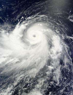
On July 4 at 0900 UTC (5 a.m. EDT) Neoguri had maximum sustained winds near 55 knots (63.2 mph/101.9 kph). It was located near 13.1 north and 141.4 east, about 207 nautical miles (238.2 miles/383.4 km) west of Andersen Air Force Base, Guam. It was moving to the northwest at 13 knots (14.9 mph/24.0 kph). This visible image from the MODIS instrument aboard NASA's Aqua satellite at 03:40 UTC on July 4 showed the bulk of the clouds and showers south and east of a clear eye.
NASA's Terra satellite passed over Neoguri as it became a typhoon on July 5. At 01:20 UTC (July 4 at 9:20 p.m. EDT) the Moderate Resolution Imaging Spectroradiometer known as MODIS that flies aboard Terra captured a visible image of Neoguri as it moved through the Northwestern Pacific Ocean. The MODIS image showed a clear eye, and a large, thick band of thunderstorms in the southern quadrant of the storm wrapping into the center.
On July 5 at 0900 UTC (5 a.m. EDT) satellite data helped confirm that Neoguri had become a typhoon in the Northwestern Pacific after it passed Guam. At that time it was centered near 16.0 north and 137.0 east, about 813 nautical miles (935.6 miles/1,506 km) southeast of Kadena Air Base. It was moving west-northwest at 14 knots (16.1 mph/25.9 kph) and had maximum sustained winds near 115 knots (132.3 mph/213.0 kph).

On July 6 Typhoon Neoguri continued to strengthen. Neoguri was located near 18.5 north and 131.4 east at 0900 UTC (5 a.m. EDT) on July 6. That's about 661 nautical miles (760.7 miles/1,224 km) southeast of Kadena Air Base, Okinawa, Japan. It had maximum sustained winds near 120 knots (138.1 mph/222.2 kph) and was moving to the west-northwest at 15 knots (17.2 mph/27.7 kph). The Joint Typhoon Warning Center or JTWC noted that Neoguri was generating very rough and high seas as high as 32 feet (9.7 meters).
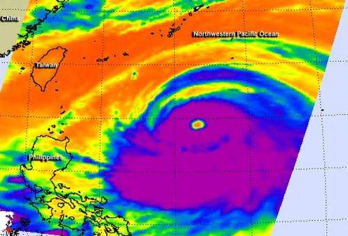
A false-colored infrared image of Supertyphoon Neoguri on July 6 at 17:17 UTC (1:17 p.m. EDT) was made at NASA's Jet Propulsion Laboratory in Pasadena, California using data from the Atmospheric Infrared Sounder (AIRS) instrument. AIRS flies aboard NASA's Aqua satellite. The infrared imagery showed very cold, high, powerful thunderstorms around the center of Neoguri's 40-nautical-mile-wide-eye and in a thick band south of the center.
By July 7 at 1500 UTC (11 a.m. EDT), Neoguri had grown into a supertyphoon with maximum sustained winds near 130 knots (149.6 mph/240.8 kph). The JTWC expects Neoguri to strengthen further. Neoguri was located near 21.6 north latitude and 127.3 east longitude, about 246 nautical miles (283.1 miles/455.6 km) south-southwest of Kadena Air Base, Okinawa, Japan. It was moving to the northwest at 15 knots (17.2 mph/27.7 kph). As Neoguri strengthened, the ocean has become more turbulent, and JTWC estimates maximum significant wave heights near 40 feet (12.1 meters).
Tropical storm-force winds extend 210 nautical miles (241.7 miles/388.9 km) from the center, and hurricane-force winds extend up to 60 nautical miles (69.0 miles/111.1 km) from the center.
For a graphic of watches in warnings in effect in Japan, visit the Japan Meteorological Agency's page: http://www.jma.go.jp/en/warn/.
Neoguri is moving northwest and continuing to strengthen. The JTWC expects Neoguri to turn to the north late on July 7 (EDT) and pass Kadena Air Base. A landfall in Kyushu is expected by July 9. The JTWC noted in a July 7 discussion: by July 9, cooling sea surface temperatures, increasing vertical wind shear ahead of the mid-latitude westerlies (winds), and landfall into Kyushu, Japan, will slowly erode the system.
Provided by NASA's Goddard Space Flight Center


