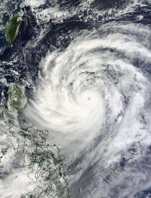
NASA sees Usagi become a typhoon

What was a tropical storm rapidly intensified into Typhoon Usagi within 24 hours as it moves through the Northwestern Pacific Ocean. NASA satellite data revealed a 20-mile-wide eye and bands of thunderstorms spiraling into the center of the monster storm.
The MODIS instrument, or Moderate Resolution Imaging Spectroradiometer aboard NASA's Terra satellite captured an amazing image of Typhoon Usagi on Sept. 19 at 02:25 UTC moving near the Philippines. The image showed spiraling bands of thunderstorms wrapping into the well-developed center of circulation and a clear eye. The bands of thunderstorms extend almost 300 nautical miles/ 345.2 miles/555.6 km to the north and about 240 nautical miles/276.2 miles/444.5 km to the south.
In 24 hours, Usagi's maximum sustained winds increased by 65 knots/75 mph/120 kph! What's interesting is that a Category one hurricane itself has maximum sustained winds near 74 mph/119 kph, and Usagi strengthened more than a category one in 24 hours.
On Sept. 19 at 0900 UTC/5 a.m. EDT, Usagi's powerful maximum sustained winds had exploded to 120 knots/138 mph/222 kph. That makes Usagi a Category 4 hurricane/typhoon on the Saffir-Simpson scale. Usagi was centered near 17.9 north and 127.6 east, about 442 nautical miles/50.6 miles/818.6 km east-northeast of Manila, Philippines. Usagi is moving to the northwest at 8 knots/9.2 mph/14.8 kph.
The Joint Typhoon Warning Center or JTWC forecast indicates that Usagi is not yet at its most powerful. Usagi is expected to continue intensifying to a peak of 140 knots/161 mph/259.3 kph over Sept. 19, and could exceed that speed, according to JTWC.
Over the next two days, Sept. 20 and 21, forecasters at the Joint Typhoon Warning Center expect Usagi to move west-northwest and pass just south of the southern tip of Taiwan before making landfall near Hong Kong on Sept. 22.
Provided by NASA's Goddard Space Flight Center


