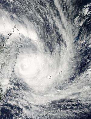
NASA sees cyclone felling squeeze between Madagascar and La Reunion

NASA satellite imagery ahowed Cyclone Felleng appear to squeeze between Madagascar and La Reunion island as it moves southward in the Mozambique Channel.
On Jan. 31 at 5:05 a.m. EST, The Moderate Resolution Imaging Spectroradiometer (MODIS) aboard NASA's Aqua satellite captured an image of Cyclone Felleng that showed thunderstorms continue to wrap around the center of circulation. The image also showed that Felleng's eye is now obscured by high clouds. The MODIS image showed that the western edge of the storm was brushing eastern Madagascar and eastern edge was over both La Reunion and Mauritius islands. Infrared satellite imagery revealed that strongest convection has been decreasing throughout the cyclone during the early morning hours of Jan. 31. Although unseen on visible satellite data, microwave imagery showed an eye feature with the deep convection confined to the eastern semi-circle.
On Jan. 31 at 1500 UTC (10 a.m. EST) Tropical Cyclone Felling was moving through the Mozambique Channel. Felleng had maximum sustained winds near 85 knots (97.8/157.4 kph). Tropical-storm-force winds extend out 140 miles (161 miles/259 km) from the center. It was centered near 18.2 south latitude and 51.1 east longitude, about 300 nautical miles (345 miles/555 km) west-northwest of LaReunion Island. Felleng is moving to the southwest at 6 knots (7 mph/11 kph). La Reunion refers to Felleng as "07/20122013." Felleng is creating very rough seas in the northern Mozambique Channel with wave heights up to 32 feet (9.7 meters).
La Reunion Island has issued a Yellow alert as Felleng continues its trek through the channel. The Yellow alert means that residents can expect strong winds, heavy rains and high swells.
The Joint Typhoon Warning Center expects Felleng to continue weakening as it moves in a southeasterly direction.
Provided by NASA's Goddard Space Flight Center


