Satellite sees 16th Atlantic tropical depression born near Bahamas

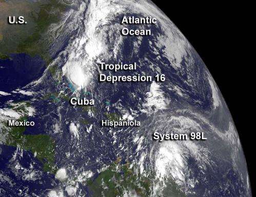
The 16th tropical depression of the Atlantic Ocean season has formed northeast of the Bahamas and NOAA's GOES-14 satellite captured a visible image of the storm as it tracks to the southwest.
NOAA's GOES-14 satellite captured a visible image of newborn Tropical Depression 16 (TD16) near the Bahamas on Oct. 11 at 7:45 a.m. EDT. TD16 appeared as a rounded area of clouds just northeast of the Bahamas and its western fringes were just off the Florida east coast. GOES-14 also showed another low pressure area with the potential for development a few hundred miles from the Windward Islands. That low appeared less organized.
At 11 a.m. EDT on Oct. 11, the newest tropical depression had maximum sustained winds near 35 mph (55 kph). It was located near latitude 25.4 north and longitude 72.6 west, about 235 miles (380 km) east-northeast of the central Bahamas. Tropical Depression 16 is just drifting to the south near 1 mph (2 kph) and according to the National Hurricane Center, is expected to turn toward the southwest and move a little faster. On the forecast track the center of TD16 is expected to remain northeast of the central Bahamas until dissipation occurs tomorrow, Friday, Oct. 12.
While TD16 lives and dies, another low pressure area is trying to find life as a depression. System 98L is a broad area of low pressure associated with a tropical wave is located about 350 miles east-southeast of the Windward Islands.
The National Hurricane Center (NHC) noted that shower and thunderstorm activity picked up today, Oct.11, and it appears to be getting better organized on GOES-14 visible satellite imagery. Some of those showers and thunderstorms may have heavy rainfall and gusty winds. Those storms will be experienced by the residents of the Lesser Antilles over the next couple of days, as System 98L moves to the west-northwest near 15 mph. Rough seas can also be expected in the Lesser Antilles from System 98L.
System 98L is in an environment favorable for development, so the NHC gives it a 50 percent chance of becoming the17th tropical depression of the season in the next couple of days.
Provided by NASA's Goddard Space Flight Center


