NASA satellite sees Tropical Storm Fami form, fast and furious

NASA's Aqua satellite caught the thirteenth tropical cyclone in the southern Indian Ocean form very quickly. In 12 hours a low grew into a tropical storm named Fami and made a fast landfall in Madagascar around 1 a.m. ET (0600 UTC) today, February 2.
At 1 a.m. ET (0600 UTC), Tropical Storm Fami had maximum sustained winds near 46 mph (40 knots) and was located in southern Madagascar, about 235 nautical miles west-southwest of Antananarivo, Madagascar. That's near 21.2 South and 43.8 East. Fami is moving east-southeast near 9 mph (8 knots).
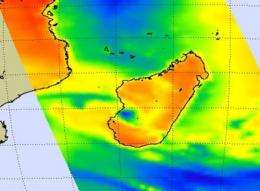
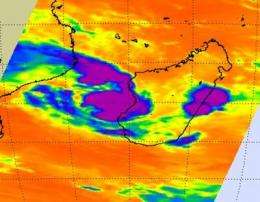
The Atmospheric Infrared Sounder (AIRS) instrument on NASA's Aqua satellite has the capability to create visible, infrared and microwave images of tropical cyclones. AIRS infrared and microwave images both showed very high, powerful thunderstorms in Fami, even now that it has made landfall. A microwave image was created combining AIRS and Advanced Microwave Sounding Unit (AMSU) data. AMSU is another instrument that flies on NASA's Aqua satellite.

The microwave image revealed that despite being over land, Fami has developed an eye feature developing in the mid- to upper-levels of the system. That is an indication that the storm is maintaining its strength, and likely feeding on tropical moisture from the warm waters that surround southern Madagascar. The microwave image also revealed cold areas in the storm that indicate ice in cloudtops and heavy precipitation. Around the eye are the coldest cloud temperatures, as cold as -63F. Microwave data suggests cloud heights to the 200 millibar level, near the tropopause.
Fami's track over the next two days and strength is one that forecasters are still pondering. One computer model forecasts that the friction caused by Fami's track over land will cause its dissipation, while another computer model (the ECMF) brings Fami back into the open ocean, then dissipating from increasing wind shear. Forecasters are watching the storm as it continues to track over land.
Provided by NASA's Goddard Space Flight Center


