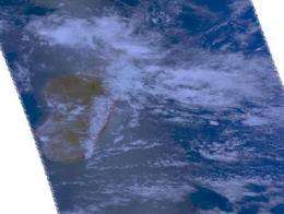
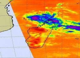
Aqua satellite sees Tropical Storm Bongani approaching Mozambique Channel

NASA's Aqua satellite flew over Cyclone Bongani today and provided some important data that have helped forecasters figure out where the storm is headed, and helped them see that it has changed course.
The Atmospheric Infrared Sounder (AIRS) instrument on NASA's Aqua satellite captured infrared, microwave and visible images of Tropical Cyclone Bongani, and provided data on cloud height and extent, cloud top temperatures, and pressure. The infrared imagery also showed that Bongani has elongated over the northern tip of Madagascar, indicating that its interaction with the land has weakened the storm.
High thunderstorm cloud tops indicate a strong storm. When the thunderstorm cloud heights start dropping, they become less cold, and the thunderstorms are less powerful. Cloud-top temperatures are important because they tell forecasters how high thunderstorms are, and the higher the thunderstorm, the colder the cloud tops and the more powerful the thunderstorms. Today's (November 25) AIRS images showed high, cold, thunderstorm cloud tops as cold as -63F. Those thunderstorms were dropping heavy rainfall.

On November 25, Bongani had maximum sustained winds near 42 mph, with higher gusts. Its center was located about 480 miles north-northeast of Antananarivo, Madagascar, near 11.6 degrees South latitude and 50.2 East longitude. Bongani was moving west-southwest near 9 mph and generating waves 12 feet high at the entrance of the Mozambique Channel.
After Bongani passes Madagascar and emerges fully into the Mozambique Channel, it is expected to re-intensify briefly before weakening.
Bongani is now forecast to head south through the Mozambique Channel and parallel the coast of Madagascar over the next 5 days.


