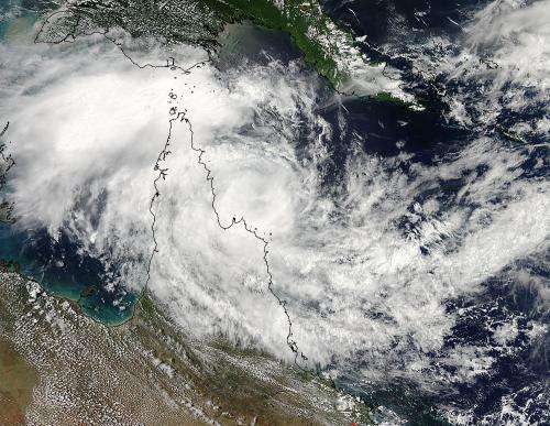
Tropical Cyclone Nathan crawling in NASA satellite imagery

Tropical Cyclone Nathan has made its cyclonic loop in the Coral Sea near Queensland, Australia's Cape York Peninsula, and is headed away from land. However, satellite imagery reveals that Nathan's movement away from Queensland is a slow crawl.
On March 13 at 1500 UTC (11 a.m. EDT), Tropical Cyclone Nathan's maximum sustained winds were near 55 knots (63 mph/102 kph). It was centered near 13.1 south latitude and 145.5 east longitude, about 229 nautical miles (263 miles/424 kph) north of Cairns, Australia. Nathan has slowed down and was moving to the east-northeast at 2 knots (2.3 mph/3.7 kph).
In a visible image taken from the MODIS instrument aboard NASA's Aqua satellite, Tropical Cyclone Nathan appeared to continue hugging the eastern coast of Queensland Australia's Cape York Peninsula as it did on March 12.
On March 13 (March 14 local time, Australia) a tropical cyclone warning was in effect from Lockhart River to Cape Flattery. For an updated forecast from the Australian Bureau of Meteorology, visit: http://www.bom.gov.au/products/IDQ65002.shtml
The Joint Typhoon Warning Center (JTWC) noted that the bulk of Nathan's convection was sheared to the west (from easterly winds). A microwave image showed tight spiral banding of thunderstorms wrapping into the low-level circulation center with weakened curved bands of thunderstorms wrapping around the western edge of the storm.
JTWC forecasts call for Nathan to move toward the east and intensify over the next two days as it will track over warm water and vertical wind shear is expected to ease.
Provided by NASA's Goddard Space Flight Center


