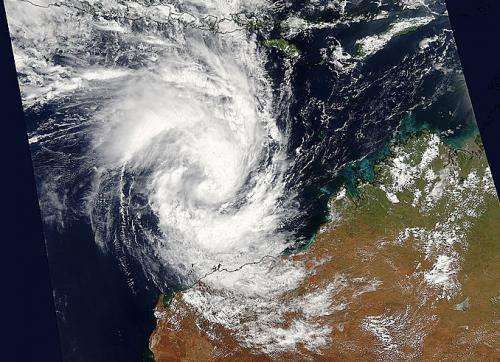
NASA captures birth of Tropical Cyclone Olwyn headed for northwestern Australia

NASA's Aqua satellite saw newly formed Tropical Cyclone Olwyn nearing northwestern Australia on March 11 when it passed overhead. Meanwhile, Tropical Cyclone Nathan was threatening northeastern Australia.
Data from the Moderate Resolution Imaging Spectroradiometer or MODIS instrument that flies aboard NASA's Aqua satellite is gathered and processed daily into images at NASA's Goddard Space Flight Center in Greenbelt, Maryland.
On March 12 at 05:50 UTC (1:50 a.m. EDT) imagery generated from the Moderate Resolution Imaging Spectroradiometer or MODIS instrument that flies aboard NASA's Aqua satellite showed Tropical Cyclone Olwyn in the Southern Indian Ocean approaching the northern coast of Western Australia.
Olwyn has generated warnings in northern Western Australia. A tropical cyclone warning is in effect for coastal areas of Western Australia from Port Hedland to Ningaloo, including Karratha, Barrow Island, Onslow, Pannawonica, Nanutarra and Exmouth (not including Port Hedland). In addition, a tropical cyclone watch is in effect from Ningaloo to Kalbarri, and adjacent inland areas of the west Pilbara and west Gascoyne, including Gascoyne Junction and Murchison Roadhouse.
In addition to the warnings and watches, the Australian Bureau of Meteorology has posted a blue alert for residents in or near Whim Creek to Coral Bay extending inland to Pannawonica. This includes people in the locations of Whim Creek, Point Samson, Wickham, Roebourne, Karratha, Dampier, Onslow, Pannawonica and Exmouth.
Olwyn has formed north of Exmouth and is forecast to move south-southwest while intensifying. At 1500 UTC (11 a.m. EST), Olwyn was centered near 17.3 south latitude and 116.0 east longitude, about 233 nautical miles (268 miles/431.5 km) northwest of Port Hedland, Australia. Olwyn is moving to the south-southwest at 12 knots (13.8 mph/22.2 kph) and has maximum sustained winds near 55 knots (63.2 mph/102 kph).
Olwyn is forecast to make landfall near Cape Cuvier in the early hours of Friday (local time) and dissipate in the interior of Western Australia.
Provided by NASA's Goddard Space Flight Center


