NASA sees Tropical Cyclone Niko's romp through society

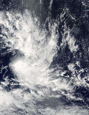
After making its social debut in the Southern Pacific Ocean, NASA's Aqua satellite spotted Tropical Cyclone Niko moving through the Society Islands.
NASA's Aqua satellite passed over Tropical Cyclone Niko on Jan. 21 at 4:35 p.m. EST and the MODIS instrument aboard captured a visible image of the storm. The MODIS images shows that the storm remains compact, while the strongest thunderstorms are pushed to the southeast of the center by northwesterly vertical wind shear.
On Jan. 22 at 0900 UTC (4 a.m. EST), Tropical Cyclone Niko's maximum sustained winds were near 50 knots (57.5 mph/92.6 kph) and strengthening. Niko was centered near 18.1 south latitude and 147.6 west longitude, about 120 nautical miles (138.1 miles/222.2 km) east-southeast of Papeete, Tahiti. Niko was moving to the southeast at 12 knots (13.8 mph/22.2 kph).
Niko is moving broadly southeast and the Joint Typhoon Warning Center forecast calls for the storm to intensify to a minimal hurricane with maximum sustained winds to 65 knots (74.8 mph/120.4 kph) on Jan. 23, before cooler waters help cause its dissipation.
Provided by NASA's Goddard Space Flight Center


