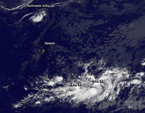
Hurricane Julio and two tropical lows 'bookend' Hawaii

Infrared satellite imagery from NOAA's GOES-West satellite shows three tropical system s in the Central Pacific Ocean that appears like bookends with Hawaii in-between.
In an infrared image from the GOES-West satellite taken August 13 at 1200 UTC (8 a.m. EDT/2 a.m. HST), Hurricane Julio lies to the north of Hawaii, while two low pressure areas lie to the southeast of the island state. The image was created by NASA/NOAA's GOES Project at NASA's Goddard Space Flight Center in Greenbelt, Maryland.
On August 13 at 0900 UTC (5 a.m. EDT/11 p.m. HST on Aug.12) the center of Hurricane Julio was located near latitude 30.0 north, longitude 158.4 west. That's about 600 miles (970 km) north of Honolulu, Hawaii. Julio was moving toward the north-northwest near 7 mph (11 kph). NOAA's Central Pacific Hurricane Center (CPHC) expects Julio to gradually turn toward the north, then to the northeast. Maximum sustained winds were near 75 mph (120 kph). The estimated minimum central pressure is 988 millibars. There are no watches or warnings in effect for Hawaii.
The Central Pacific Hurricane Center noted that vertical wind shear should begin to affect the hurricane by Thursday, August 15 as Julio tracks into cooler waters. The combination of those two factors is expected to weaken Julio to tropical storm status as it turns to the northeast over open waters in the Central Pacific Ocean.
Far to the southeast of Julio and southeast of the Hawaiian Islands are two slowly developing areas of tropical low pressure.
The first area is a disorganized area of showers and thunderstorms, and is located along a trough (elongated area) of low pressure about 950 miles southeast of Hilo, Hawaii. This system is expected to develop slowly, or not at all, as it moves west-northwest at 10 to 15 mph. The CPHC gives it just a 10 percent chance of becoming a tropical depression in the next two days.
The second area is an elongated area of low pressure, generating showers and thunderstorms. That low is centered about 1380 miles east-southeast of Hilo, Hawaii and is in the westernmost fringe of the Eastern Pacific Ocean. CPHC said that this system may develop slowly as it moves west-northwest at 10 to 15 mph. If it does develop, this system may enter the central Pacific basin as early as tonight, August 13. CPHC gives the second low a 20 percent chance of formation over the next two days.
Provided by NASA's Goddard Space Flight Center


