NASA's Aqua satellite reveals Tropical Cyclone Ita strengthening

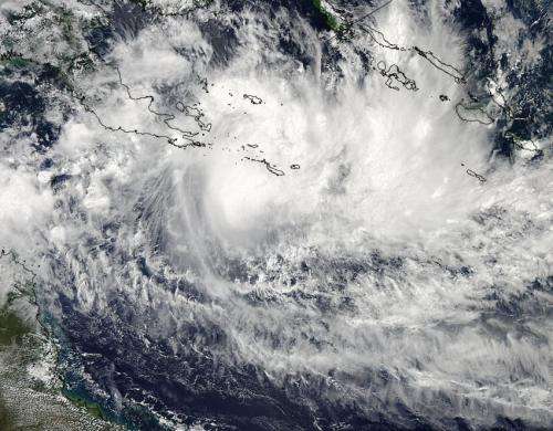
Tropical Cyclone Ita's maximum sustained winds have increased over the last day and NASA's Aqua satellite provided forecasters at the Joint Typhoon Warning Center with a visible look at the storm on April 8.
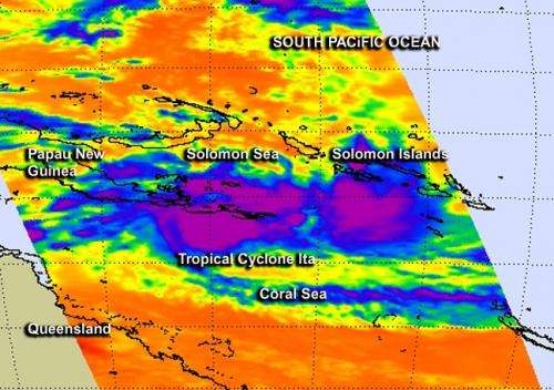
NASA's Aqua satellite passed over Ita at 3:30 UTC/11:30 p.m. EDT on April 7, and the Moderate Resolution Imaging Spectroradiometer provided a visible image of Tropical Cyclone Ita. The MODIS image showed a large area of strong thunderstorms south and northeast of the center of circulation. At the same time, the Atmospheric Infrared Sounder or AIRS instrument aboard Aqua gathered infrared data on the storm, revealing very cold cloud top temperatures near -63F/-52C, and indicative that the storm was strengthening. When cloud tops cool there is more uplift or energy in the atmosphere to push them higher into the troposphere. The stronger the push the higher the cloud tops go and that means the potential for stronger thunderstorms.
At 900 UTC/5 a.m. EDT, Ita's maximum sustained winds were near 65 knots/74.8 mph/120.4 kph. It was centered near 11.5 south and 152.2. east, about 507 nautical miles/583.4 miles/939 km northeast of Cairns, Queensland, Australia. Ita was moving to the west-northwest at 3 knots/3.4 mph/5.5 kph, but is expected to move in a more west-southwesterly direction.

Animated multispectral satellite imagery showed that the low-level center of circulation is consolidating. Ita is moving away from Sudest Island today, April 8. An image from the Advanced Microwave Sounding Unit showed that the center is surrounded by tightly curved bands of thunderstorms along the eastern semi-circle. The AMSU-A aboard NASA's Aqua satellite is part of a closely coupled triplet of instruments that include the AIRS (Atmospheric Infrared Sounder) and HSB (Humidity Sounder for Brazil). AMSU-A on Aqua is a 15-channel microwave sounder instrument designed primarily to obtain temperature profiles in the upper atmosphere (especially the stratosphere) and to provide a cloud-filtering capability for tropospheric temperature observations
Forecasters at the JTWC or Joint Typhoon Warning Center forecast Ita to accelerate westward to west-southwestward as a mid-level subtropical ridge (elongated area of high pressure) builds over the Coral Sea. JTWC forecasters then expect Ita to head toward Queensland Australia's Cape York Peninsula over the next three days.
Provided by NASA's Goddard Space Flight Center


