October 22, 2013 report
Scientists discover satellites captured Chelyabinsk meteor debris trail

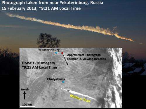
(Phys.org) —A team of researchers with members from Colorado State University, the University of Wisconsin and NOAA has found that several satellites orbiting the Earth at the time of the Chelyabinsk meteor explosion captured the debris trail on film. As the team explains in their paper published in Proceedings of the National Academy of Sciences, the captured images allowed for calculating the trajectory of the meteor and then its orbit.
The Chelyabinsk explosion that occurred in the stratosphere over Russia this past February was a stark reminder of the dangers posed by meteors—the resulting shock wave injured over 1000 people and caused damage across the region. Because of their relatively small size, modern science has still not been able to come up with a way to see such meteors before they strike the earth. The Chelyabinsk meteor was a complete surprise—no one knew of its existence until it exploded. For that reason, scientists continue to look for new tools to help with forecasting. In this new effort, the researchers wondered if American weather satellites had captured the strike and if so, if they might provide any new information.
After studying imagery from multiple satellites, the team discovered that several of them had indeed captured images of the debris trail, some just moments after the meteor exploded. Analyzing the images allowed for calculating the trajectory of the meteor and from that, its prior orbit. Scientist's had already done the same using photographs taken by people in Russia, of course, but because the calculations matched so closely, the researchers were able to confirm that images of satellites can be used to provide accurate data about meteor events that are not recorded in other ways.
Calculating trajectories and orbits is important because it's believed that up to 15 percent of meteors travel in pairs, or even as triplets. If scientists can very quickly calculate the trajectory of a strike, they can look to see if more are coming, possibly saving lives. Also, if meteor detection is built into satellites in the future, they could conceivably report on the actual number and locations of strikes around the world—as things stand now it's possible that relatively small meteors strike fairly regularly in remote locations or in the ocean and nobody knows its happening.
More information: Earth-viewing satellite perspectives on the Chelyabinsk meteor event, PNAS, Published online before print October 21, 2013, DOI: 10.1073/pnas.1307965110
Abstract
Large meteors (or superbolides [Ceplecha Z, et al. (1999) Meteoroids 1998:37–54]), although rare in recorded history, give sobering testimony to civilization's inherent vulnerability. A not-so-subtle reminder came on the morning of February 15, 2013, when a large meteoroid hurtled into the Earth's atmosphere, forming a superbolide near the city of Chelyabinsnk, Russia, ∼1,500 km east of Moscow, Russia [Ivanova MA, et al. (2013) Abstracts of the 76th Annual Meeting of the Meteoritical Society, 5366]. The object exploded in the stratosphere, and the ensuing shock wave blasted the city of Chelyabinsk, damaging structures and injuring hundreds. Details of trajectory are important for determining its specific source, the likelihood of future events, and potential mitigation measures. Earth-viewing environmental satellites can assist in these assessments. Here we examine satellite observations of the Chelyabinsk superbolide debris trail, collected within minutes of its entry. Estimates of trajectory are derived from differential views of the significantly parallax-displaced [e.g., Hasler AF (1981) Bull Am Meteor Soc 52:194–212] debris trail. The 282.7 ± 2.3° azimuth of trajectory, 18.5 ± 3.8° slope to the horizontal, and 17.7 ± 0.5 km/s velocity derived from these satellites agree well with parameters inferred from the wealth of surface-based photographs and amateur videos. More importantly, the results demonstrate the general ability of Earth-viewing satellites to provide valuable insight on trajectory reconstruction in the more likely scenario of sparse or nonexistent surface observations.
Journal information: Proceedings of the National Academy of Sciences
© 2013 Phys.org


