NASA sees heavy rain in Typhoon Francisco, now affecting southern Japanese islands

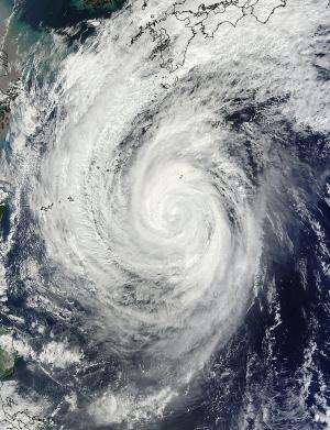
On Oct. 22, 2013 Typhoon Francisco was already affecting the southern islands Japan when the TRMM satellite had a good view of its rainfall and cloud heights.
On Oct. 23, as Typhoon Francisco moved closer to Japan's southern islands, the Daito islands and islands of Okinawa (including Kadena Air Base) and Amami-Oshima were all receiving rainfall, gusty winds and strong surf. Those islands are under warnings and facing high waves, gale-force winds, storm surge and heavy rainfall.
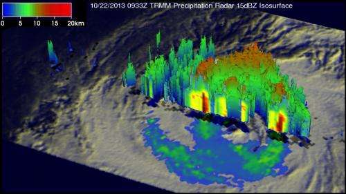
On Oct. 22 at 0933 UTC/5:33 a.m. EDT NASA's Tropical Rainfall Measuring Mission or TRMM satellite passed over Francisco. At that time Francisco was weakening and had estimated winds of less than 75 knots/~86 mph. An analysis derived from TRMM's Microwave Imager (TMI) and Precipitation Radar (PR) instruments was overlaid on an enhanced infrared image from TRMM's Visible and InfraRed Scanner (VIRS). That analysis showed that the most intense rain was falling at a rate of over 75mm/~3 inches per hour in a location well to the southwest of Francisco's center of circulation.
Data from TRMM's Precipitation Radar (PR) instrument was used to create a 3-D view (from the northwest) of typhoon Francisco's vertical structure. The tallest thunderstorm towers, reaching to heights of about 12km/~7.4 miles, were measured by TRMM PR in a band of storms also at a great distance from the center of the typhoon.

On Oct. 23 at 0900 UTC/5 a.m. EDT, Typhoon Francisco had maximum sustained winds near 70 knots/80.5 mph/129.6 kph. It was centered near 24.6 north latitude and 130.4 east longitude, about 197 nautical miles/226.7 miles/264.8 km southeast of Kadena Air Base. Francisco was moving to the west-northwest, and is expected to turn to the northeast in the next day.
Typhoon Francisco is predicted to continue weakening and start moving toward the northwest. Francisco is then predicted to pass to the southeast of Japan's main island of Honshu as a strong tropical storm.
Provided by NASA's Goddard Space Flight Center


