Satellite sees Tropical Storm Gabrielle battling wind shear, gulf storm developing

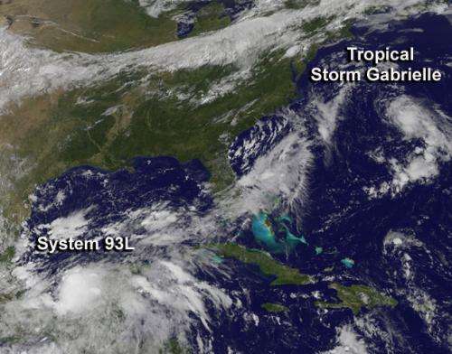
Gabrielle is a fighter. Tropical Storm Gabrielle regained tropical storm status on Sept. 12 at 11 a.m. EDT after being knocked down to tropical depression status earlier in the day. NASA's GOES Project used NOAA's GOES-East satellite data to create an image that showed wind shear is still having a big effect on Gabrielle, and another low pressure area appears to be organizing in the Gulf of Mexico.
At 11 a.m. EDT on Sept. 12, Tropical Depression Gabrielle's center was 200 miles/325 km northwest of Bermuda, and about 530 miles/850 km south-southeast of Nantucket, Mass. near 33.9 north and 67.7 west. NOAA's GOES-East satellite showed Gabrielle's center far east of the Mid-Atlantic coast, more than 1,000 kilometers (over 600 miles) northeast of the border between North and South Carolina.
The bulk of clouds and showers associated with Gabrielle were pushed far to the northeast of the center, because southwesterly wind shear continues to push them away. Those displaced clouds were apparent on NOAA's GOES satellite imagery. The image was created by NASA's GOES Project at the NASA Goddard Space Flight Center in Greenbelt, Md. NASA's GOES Project also created an animation of GOES imagery from Sept. 10 through 12 that shows Gabrielle weakening from a tropical storm to a depression and strengthening back to a tropical storm again.
Tropical Depression Gabrielle's maximum sustained winds were back up to near 40 mph/65 kph after dropping below that threshold for tropical storm status earlier in the day. Gabrielle was moving to the north at 8 mph/13 kph and is expected to turn north-northeast and speed up as it is expected to transition into an extra-tropical storm over the next day.
As Gabrielle heads toward transition, another low pressure area in the Atlantic basin appears ripe for a transition in satellite imagery. The low pressure area known as System 93L, located in the southwestern Gulf of Mexico now has a high chance to become a tropical depression. System 93L is in the Bay of Campeche, located west of the Yucatan Peninsula. The Bay is in the southwestern part of the Gulf of Mexico. The low is in the same area where tropical depression 8 was born earlier this season
NOAA's GOES-East satellite captured in one image both Gabrielle and System 93L at 1431 UTC/10:31 a.m. EDT. The image showed Gabrielle's clouds northeast of center, while System 93L's thunderstorms appeared around the center of its circulation.
The National Hurricane Center (NHC) noted that environmental conditions appear to be favorable for development and System 93L now has a high chance of becoming a tropical cyclone during the next two days. NHC noted that System 93L is forecast to move very slowly across the southern Gulf of Mexico producing locally heavy rains over a large part of eastern Mexico during the next several days.
Provided by NASA's Goddard Space Flight Center


