TRMM satellite sees Tropical Storm Erick along Mexican coast

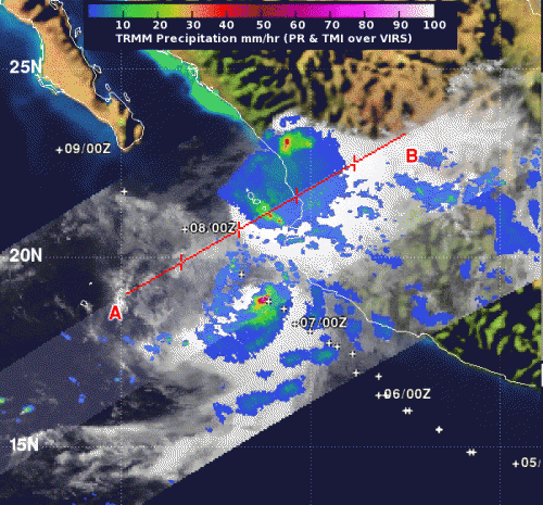
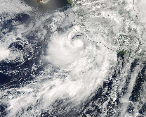
Tropical Storm Erick has been bringing some rain and rough surf along the southwestern coast of Mexico for a couple of days, and on July 7, 2013, NASA's TRMM satellite saw two areas of heavy rain within Erick on opposite ends of the storm. Meanwhile, the rainfall from the remnants of nearby Tropical Depression Dalila had dissipated.
When NASA's Tropical Rainfall Measuring Mission or TRMM satellite passed over Tropical Storm Erick on Sunday, July 7, it measured rainfall rates as seen from space. TRMM showed that the northeastern quadrant and southwestern quadrants had the strongest areas of rainfall. Small areas in each quadrant showed rainfall rates near 2 inches/50 mm per hour.
The southwestern quadrant was over the open waters of the Eastern Pacific Ocean, while the northeastern quadrant was near the towns of Acponeta and Tecuala, in the northern part of the Mexican state of Nayarit. Both towns are located south of Mazatlan along the southwestern coast of Mexico. TRMM data also showed that a thunderstorm that was generating one of the areas of heavy rainfall was almost 15 kilometers (9.3 miles) high.
A tropical storm warning is in force for Baja California Sur from Santa Fe to La Paz, and the National Hurricane Center expects rainfall totals of between 1 and 3 inches over the southern Baja California peninsula. Rough surf and ocean swells are already affecting southern Baja California later and can cause life-threatening surf and rip currents.

At 9 a.m. EDT/6 a.m. PDT, La Paz on the southern tip of Baja California had overcast skies, while Mazatlan on the southwestern coast of mainland Mexico had showers from the eastern-most extent of Tropical Storm Erick.
At 5 a.m. PDT (8 a.m. EDT), the center of Tropical Storm Erick was about 85 miles (135 km) south of the southern tip of Baja California, near latitude 21.7 north and longitude 109.7 west. Maximum sustained winds were near 50 mph (85 kph) and Erick is forecast to weaken over the next two days. The estimated minimum central pressure is 998 millibars.
Erick was moving toward the northwest near 9 mph (15 kph) and is expected to continue in that direction for a day or two before turning to the west-northwest by July 10. The center of Erick is expected to pass just south of the tip of Baja California later today.
Meanwhile, nearby Tropical Depression Dalia has dissipated. On Sunday, July 7, Dalila became a remnant low pressure area and was downgraded as of 5 a.m. EDT. Dalila's remnants were last located near 16.8 north and 113.0 west, about 465 miles (750 km) south-southwest of the southern tip of Baja California. Maximum sustained winds were near 30 mph (45 kph) at that time and the remnants were crawling to the southeast at 1 mph (2 kph). Dalila weakened further overnight and dissipated early on July 8.
Provided by NASA's Goddard Space Flight Center


