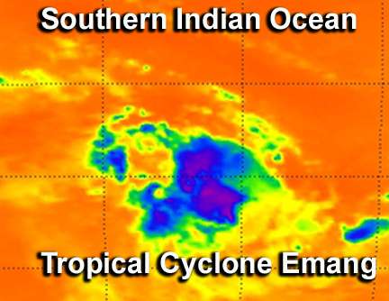
Infrared NASA imagery shows sinking air, elongation in Tropical Storm Emang

The Atmospheric Infrared Sounder instrument that flies on NASA's Aqua satellite provides valuable data to tropical cyclone forecasters, and revealed sinking air, a small area of powerful thunderstorms, and a slightly elongated Tropical Storm Emang.
Infrared data on Tropical Storm Emang's cloud top temperatures was captured by the Atmospheric Infrared Sounder (AIRS) instrument on Jan. 15 at 0823 UTC (3:23 a.m. EST). AIRS data showed that the largest area of powerful thunderstorms were in the northern half of the storm. That area showed cold cloud top temperatures of -63F (-52C) indicating high, powerful thunderstorms where the heaviest rain was falling.
The AIRS data also showed that sinking air or subsidence was occurring in the southwestern quadrant of the storm, which is weakening the convection there.
AIRS data also showed that the low level center of circulation had become slightly elongated, stretching from southwest to northeast. For a tropical cyclone to intensify, its circulation centers from the surface to upper atmosphere basically have to stack up. When the center becomes elongated the storm usually has a difficult time intensifying.
On Jan. 15 at 0900 UTC, Tropical Storm Emang's maximum sustained winds were near 35 knots (40.2 mph/64.8 kph). Emang is moving slowly to the south-southwest at 4 knots (4.6 mph/7.4 kph). Emang was centered near 13.5 south latitude and 78.6 east longitude, about 525 nautical miles (604.2 miles/ 972.3 km) southeast of Diego Garcia. Diego Garcia is a coral atoll in the central southern Indian Ocean.
Forecasters at the Joint Typhoon Warning Center expect atmospheric conditions to improve over the coming days, so that Emang can organize and strengthen. Fortunately, the storm is no threat to land.
Provided by NASA's Goddard Space Flight Center


