NASA satellite captured Hurricane Leslie's picture perfect moment

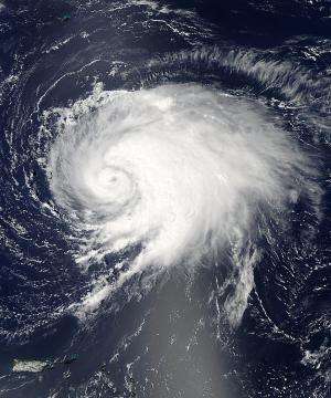
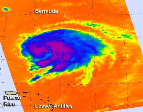
NASA's Aqua satellite flew over Tropical Storm Leslie on Sept. 5 during a picture perfect moment, just as it was being re-classified as a hurricane, and captured two images of the storm.
The National Hurricane Center issued the advisory confirming Leslie's hurricane status at 1:45 p.m. EDT after examining visible, infrared, microwave and other data from satellites. Two instruments that fly aboard NASA's Aqua satellite provided infrared and visible imagery of Leslie as it was crossing the threshold from tropical storm to hurricane status on Sept. 5.
The Moderate Resolution Imaging Spectroradiometer (MODIS) instrument provided a visible image of Hurricane Leslie on Sept. 5 at 1:15 p.m. EDT as the storm was approaching Bermuda. The MODIS image showed that an eye had just formed in Leslie.

The Atmospheric Infrared Sounder (AIRS) instrument also aboard Aqua captured infrared data at the same time. The AIRS data showed the strongest thunderstorms and coldest cloud top temperatures were wrapped in a large area around the center of circulation and in a wide band of thunderstorms to the east and south of the center. Cloud top temperatures in both areas were colder than -63 Fahrenheit (-52 Celsius). On Sept. 6, the strongest convection (rising air forming the thunderstorms that make up the cyclone) and coldest cloud top temperatures were east of the center of circulation as a result of westerly wind shear.
On Sept. 6 at 8 a.m. EDT, Leslie had maximum sustained winds near 75 mph (120 kmh). The area of tropical storm force winds now extend outward up to 195 miles (315 km). Leslie's center was about 440 miles (705 km) south-southeast of Bermuda, near latitude 26.3 north and longitude 62.4 west. Leslie is slowly drifting toward the northeast near 1 mph (2 kmh) and is expected to continue drifting in that direction through Friday, Sept. 7.
Leslie continues to cause a lot of rough surf in a large area. Warnings for rough seas, swells and rip tides are in effect for Bermuda, the U.S. east coast from central Florida northward, the Northern Leeward Islands, Puerto Rico and the Virgin Islands for the next couple of days.
Leslie's slow movement continues to bring up cooler waters from below the surface of the ocean, which will be detrimental to its intensification. However, the wind shear is expected to decrease and Leslie is expected to move northward, so the National Hurricane Center expects that Leslie may intensify over the next couple of days. Leslie is forecast to pass east of Bermuda on Sunday, Sept. 9 as a hurricane.
Provided by NASA's Goddard Space Flight Center


