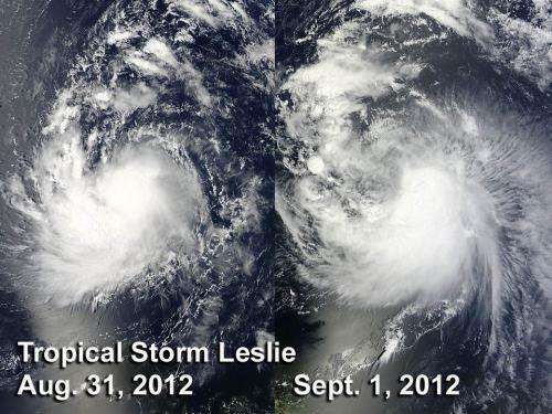
NASA satellites showed little change in Tropical Storm Leslie

Over the weekend of Aug. 31 to Sept. 2, Tropical Storm Leslie's maximum sustained winds were pretty constant and satellite imagery from NASA's Aqua and Terra satellites confirm the steadiness of the storm. That story is expected to change later this week however, as Leslie nears Bermuda and is expected to reach hurricane strength. Meanwhile, Leslie is still about the same strength today, Sept. 4 because of wind shear.
Two visible images from the Moderate Resolution Imaging Spectroradiometer or MODIS instrument that flies onboard both of NASA's Aqua and Terra satellites showed that Tropical Storm Leslie didn't change much in terms of form or strength from Aug. 31 at 12:55 p.m. EDT to Sept. 1 10:30 a.m. EDT. Leslie's shape appeared almost identical in a 22 hour period at a time that its maximum sustained winds were near 60 mph (95 kmh).
On Sept. 4 at 11 a.m. EDT, Tropical Storm Leslie's maximum sustained winds had still not changed much from the time NASA's two satellites passed over it on the weekend. Maximum sustained winds were now up to 65 mph (100 kmh). Leslie is about 410 miles (670 km) in diameter, as tropical-storm force winds extend up to 205 miles (335 km) from the center.
The National Hurricane Center noted that Leslie's path may become somewhat erratic over the next couple od days on its northward journey.
Leslie was located about 525 miles (840 km) south-southeast of Bermuda, near latitude 25.0 north and longitude 62.5 west. Leslie is moving toward the north near 3 mph (6 kmh) and is expected to continue moving slowly in that direction.
Ocean swells from Tropical Storm Leslie may affect the Leeward Islands, Puerto Rico and the Virgin Islands, and those conditions are expected to spread to Bermuda and the eastern U.S.
Satellite data on Sept. 4 showed that the rising air that forms the thunderstorms that make up the storm (convection) has decreased near Leslie's center. Leslie is being battered by wind shear from the northwest at 20 knots, which is pushing the showers and thunderstorms to the southeast. The National Hurricane Center update at 11 a.m. EDT noted that "the convective cloud structure now more resembles a curved band pattern [than a circular tropical cyclone]." In fact, the low-level center of Leslie appears to be 30 miles north of the mid-level center. That's important because the centers of tropical cyclones need to be stacked on top of each other like a coiled spring, in order to rotate and intensify. Basically, it means that Leslie is struggling.
That environment is expected to change, though, as Leslie moves north and wind shear relaxes, giving the storm a chance to organize. That's why the National Hurricane Center expects Leslie to strengthen into a hurricane by the end of the week.
Provided by NASA's Goddard Space Flight Center


