NASA measuring Tropical Storm Debby's heavy rains from space

Tropical Storm Debby continues to be a big rainmaker in Florida and southern Georgia and NASA's TRMM satellite has measured those rainfall rates from space, showing where heavy rain has fallen.
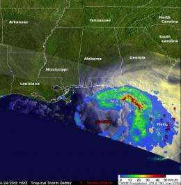
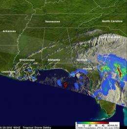
The Tropical Rainfall Measuring Mission (TRMM) satellite is basically a flying rain gauge in space. Scientists use TRMM data to calculate rainfall rates and rain totals from space. TRMM imagery from June 25 showed Debby's heaviest rains were falling at a rate of over 2 inches (50 mm) per hour, and to the southeast of the center.
Debby has been a huge rainmaker. For example, Debby dumped nearly 7 inches of rain on Gainesville Sunday, June 24. That was Gainsville's second highest one day total. Numerous other reports of between 6 and 10 inches of rain have already been reported as a result of Debby.
Debby's Status Today:
Today, June 25, 2012, a tropical storm warning is in effect for the Florida Gulf coast from Mexico Beach to Englewood. At 8 a.m. EDT (1200 UTC), Debby had maximum sustained winds near 45 mph (75 kmh). It was still centered in the northeastern Gulf of Mexico, about 85 miles (140 km) west of Cedar Key, near 28.9 north latitude and 84.5 west longitude. The estimated minimum central pressure is 991 millibars. Debby is slowly moving toward the east near 3 mph (6 kmh) and is expected to move east-northeastward in the next couple of days, according to the National Hurricane Center (NHC). NHC forecasters note that Debby's center will weaken to a depression while moving over northern Florida in the next day or two.

Debby's History:
Tropical Storm Debby formed on the 23rd of June 2012 in the central Gulf of Mexico, becoming the earliest 4th named storm on record. Debby began as an area of low pressure that moved out of the northwestern Caribbean and into the Gulf. After forming on the afternoon of the 23rd, Debby has moved very slowly under the influence of weak steering currents.
Debby drifted ever so slowly northward on the night of the 23rd before turning northeast later on the morning of the 24th towards the northeast Gulf Coast of Florida. Despite its slow forward progress and lack of intensification, Debby has already lashed Florida with heavy rain as well as tornadoes.
What TRMM Data Reveals:
The Tropical Rainfall Measuring Mission (or TRMM) satellite captured an image of Debby when it passed over the storm in the north central Gulf of Mexico on the morning of June 24 at 11:51 UTC (6:51 a.m. CDT). TRMM revealed that most of the rain associated with Debby is well away from the center. A large area of moderate rain north and east of the center extends from near Tampa Bay all the way around to near Panama City. A large band of intense rain lay just off shore, while light to moderate rain covered a broad area of the Florida peninsula.
How Rainfall is Mapped:
Data from several TRMM instruments are used to create rainfall images at NASA's Goddard Space Flight Center in Greenbelt, Md. Rain rates in the center of image swaths are from the TRMM Precipitation Radar (PR), while those in the outer swaths are from the TRMM Microwave Imager (TMI). The rain rates are then overlaid on infrared (IR) and visible data from the TRMM Visible Infrared Scanner (VIRS). TRMM is a joint mission between NASA and the Japanese space agency JAXA.
Coastal flooding and the potential for isolated tornadoes are continuing threats today. The storm is also expected to continue to bring very heavy rains to northern and central Florida where some areas could see in excess of 20 inches of rain. Storm speed is what matters most when it comes to rainfall; the slower the storm, the more time it has to rain over a given area.
Provided by NASA's Goddard Space Flight Center


