NASA sees powerful Typhoon Guchol affecting Kadena Air Base

All hatches should be battened down at Kadena Air Base, Japan as NASA satellite imagery today, June 18, revealed the northern quadrant of Typhoon Guchol as already affecting the island.
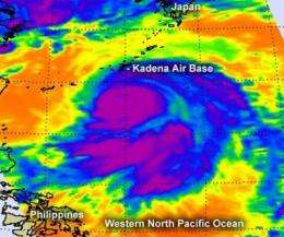
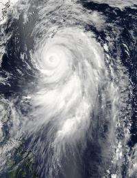
The Moderate Resolution Imaging Spectroradiometer (MODIS) instrument onboard NASA's Aqua satellite captured a visible image of Typhoon Guchol on June 18, 2012 at 0445 UTC (12:45 a.m. EDT/U.S.). Guchol is approaching Kadena Air Base. The image showed high cirrus clouds over Guchol's eye. The Atmospheric Infrared Sounder instrument onboard Aqua captured an infrared image that revealed powerful thunderstorms over a large area surrounding the eye, that had very cold cloud top temperatures (colder than -63F/-52C). The infrared image also revealed bands of thunderstorms east and south of the center.

On June 18 at 0900 UTC (5 a.m. EDT/U.S.) Guchol has maximum sustained wind near 105 knots (120.8 mph/194.5 kph), which makes it a Category three typhoon on the Saffir-Simpson scale. Typhoon-force winds extend 55 nautical miles (63 miles/102 km) from the center, while tropical-storm-force winds extend 165
nautical miles (190 miles/305 km), making the storm about 330 nautical miles (380 miles/611 km) in diameter. Guchol's storm surges pose a big threat, as it is generating 52 foot-high (~16 meters) seas.
At 9:35 p.m. EDT on June 17, the Kadena Air Base Facebook page reported "The 18th Wing commander announced TCCOR 1: Destructive sustained winds of 50 knots [57.5 mph/92.6 kph] or greater are expected within 12 hours. DODDs schools will close at this time. Fill any available containers with water. Make a final check of food, water and other supplies." Kadena Air Base will experience rough surf, heavy rainfall and typhoon-force winds from June 18 to 20 as the storm moves north.
Guchol is moving north toward the big Island of Japan and expected to track near Kyoto. Guchol continues to weaken and is expected to become extra-tropical while moving over Japan.
Provided by NASA's Goddard Space Flight Center


