NASA satellites feed forecasters information as Bud becomes a hurricane

Bud has now become the first hurricane of the eastern Pacific Hurricane Season, as NASA visible and infrared satellite imagery revealed an organized structure of spiraling thunderstorms around the eye. Watches and warnings are already in effect for southwestern Mexico as Bud nears.
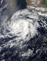
The Moderate Resolution Imaging Spectroradiometer (MODIS) instrument onboard NASA's Aqua satellite captured a visible image of Hurricane Bud off the southwestern coast of Mexico on May 23 at 2035 UTC (1:35 PDT) before it reached hurricane status. The image showed the outer fringes of Bud's clouds are brushing the Mexican coast, despite the center being hundreds of miles offshore. Brighter white clouds indicate higher clouds and stronger thunderstorms near the center and banding on the eastern side of the storm.
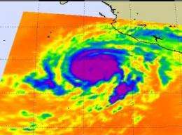
Imagery from NASA's Atmospheric Infrared Sounder (AIRS) instrument onboard NASA's Aqua satellite was taken on May 24 at 0847 UTC (4:47 a.m. EDT) shows a large area of high, cold cloud tops around Bud's eye. The strongest storms appear in purple and have a cloud top temperature colder than -63F (-52C).

A tropical storm warning is in effect for the coast of Mexico from Punta San Telmo Westward to Cabo Corrientes, and a hurricane watch is in effect for the coast of Mexico from Punta San Telmo Westward to Cabo Corrientes.
At 11 a.m. EDT (8 a.m. PDT) on May 24, Bud has sustained winds near 105 mph (165 kph) with higher gusts. Bud is a category two hurricane on the Saffir-Simpson hurricane wind scale. The National Hurricane Center expects additional strengthening today before Bud begins weakening early Friday. Those hurricane force winds stretch out 25 miles (35 km) from the center, while the tropical storm-force winds extend up to 105 miles (165 km) from the center.
Bud was located about 280 miles (445 km) southwest of Manzanillo, Mexico, near latitude 15.7 north and longitude 106.7 west and is moving north-northeast near 8 mph (13 kph). Forecasters expect Bud to slow down.
The center of Bud will be near or just offshore of the southwestern coast of Mexico late Friday and Saturday, and is not expected to make landfall, but will cause a lot of problems with heavy rain, strong winds, and dangerous surf before it turns around and heads back into the open waters of the eastern Pacific.
Forecasters at the National Hurricane Center said that means "rainfall totals of 4 to 6 inches, locally up to 10 inches are expected in the states of Michoaca, Colima, Jalisco and southern Nayarit. Life threatening flash floods and mudslides are possible." Bud is already stirring up the surf along the southwestern Mexico coasts today, and will cause life-threatening surf conditions and swells.
Provided by NASA's Goddard Space Flight Center


