New map shows makeup of British landscape

Scientists have released a digital map that shows in unprecedented detail the mosaic of vegetation and land-cover types that makes up the British landscape.
The map will help improve our understanding of how we are using the land, and how we can manage it sustainably in the future.
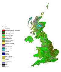
The new UK Land Cover Map (LCM) is the product of several years' work. It's based on 70 satellite images collected between 2005 and 2008, and shows the distribution of different habitats around the UK to a resolution of just 25 metres.
"At a time when our land surface is under increasing pressure, reliable information on land cover is essential," says Dr. Dan Morton of the Center for Ecology & Hydrology (CEH), who led the project. "The demands that we place on our land are often conflicting and need to be balanced to maintain and enhance our quality of life. To address these issues and plan for the future, we need to know what we have on our land surface and where it is. The new map provides that information."
He suggests it will be helpful to scientists in many fields, from researchers trying to understand how water drains off the land to those working on how carbon moves through particular ecosystems, or how to manage our natural resources most efficiently.
Morton is involved with a project that's trying to understand the decline in insect pollinators, and how this relates to changes in farming techniques and land cover over the last few decades. His group will use the land cover map to choose representative areas that can be studied in greater detail, comparing the latest map with the results of previous mapping exercises to try to understand how land cover has changed, and how this relates to the worrying decline in pollinators.
The subject isn't of interest only to ecologists. Many crops depend on these pollinators, so if their numbers keep falling we may have to wave goodbye to many favorite foods, from strawberries to apples.
To produce the map, the scientists analysed the satellite photos by computer and used their colours to work out what kind of vegetation is growing there. Based on this, each area was assigned to a land cover type based on existing Biodiversity Action Plan habitat categories.
The scientists then used the results to fill in some ten million 'land parcel' shapes taken from Ordinance Survey data; although OS maps are so finely detailed - accurate to around a metre in urban areas - that they had to throw out a lot of the information to match the much lower resolution of the satellite data.
The results show that the main categories of land use, 'Arable and horticulture' and 'improved grassland' habitats, both take up a quarter of the UK's land area. 'Semi-natural grassland' takes up 13 per cent; 'mountain, heath and bog' accounts for another 16 per cent. 'Urban areas', 'coniferous woodland', 'broadleaved woodland' each make up a further 6 per cent, while 'coastal' and 'freshwater' habitats account for the rest.
The approach taken for this LCM overcomes some of the disadvantages of the OS maps, which generally show only boundaries like hedges, ditches and roads. "Once you get above the enclosure level and into an upland area, there are often no boundaries on which to base the outlines of the land parcels," Morton notes. "But these landscapes are often still very heterogeneous in terms of the habitats they contain, and we need to pick up these differences."
CEH produces the LCM every decade on behalf of the long-running Countryside Survey partnership. Previous versions came out in 1990 and 2000. Morton says his team have not yet done much work on how the breakdown of UK habitats has changed compared to previous years, but that doing so will help highlight emerging trends and let us manage the landscape for the benefit of future generations.
Source: PlanetEarth Online


