This article has been reviewed according to Science X's editorial process and policies. Editors have highlighted the following attributes while ensuring the content's credibility:
fact-checked
trusted source
proofread
Real-time flood risk visualization via server-based mixed reality enhances accessibility and public safety

Climate change is increasing flood risks in urban areas, with heavy rainfall disasters now becoming a global problem. Numerical simulations predict flooding from heavy rain and river overflows, usually displaying results on flat maps. However, map scale can limit detailed risk assessment, making it difficult for residents to fully understand flood risks.
Now, researchers from Osaka University have developed a mobile mixed reality (MR) system as a powerful tool for real-time flood risk visualization through server-based rendering and web-based access. This allows urban populations to view dynamic flood forecasts on their mobile devices, enhancing community preparedness and response. The work is published in the journal Environmental Modelling & Software.
By offloading the computational workload to a server, MR displays can be rendered efficiently, allowing real-time visualization on commonly-used mobile devices such as smartphones.
Access to these MR displays is streamlined through web browsers, eliminating the need for specialized applications. This accessibility means that multiple devices can connect simultaneously, enabling widespread participation in MR visualizations. The system intelligently assigns the optimal server from a pool of rendering servers, ensuring efficient performance and scalability.
This approach democratizes access to advanced flood forecasting tools, making it feasible for many users to engage with MR visualizations without the constraints of dedicated software.
-
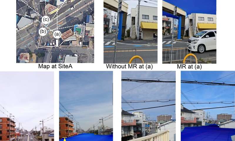
Examples of MR images displayed on a smartphone. (a) is a viewpoint from below the flooded surface; (b) and (c) are from above the flooded surface, looking down from a pedestrian bridge. Credit: 2024 Ryoma Tsujimoto et al., Environmental Modelling & Software -
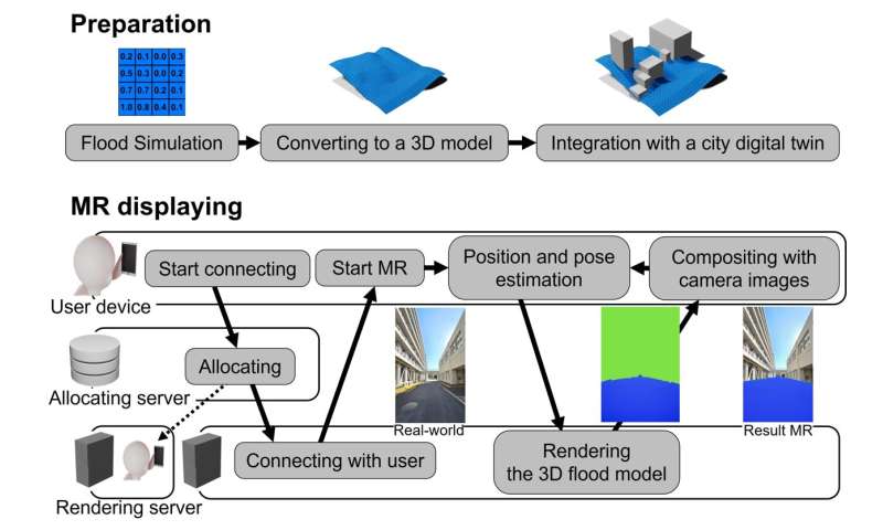
Overview of the proposed system. The upper part shows the preliminary preparation procedure, and the lower part shows the actual MR display flow. Credit: 2024 Ryoma Tsujimoto et al.
"As climate change heightens flood risks, mitigating these risks is crucial," says lead author of the study Ryoma Tsujimoto.
"We expect that our study will help people to intuitively understand flooding risks, regardless of their expertise, and that eventually, social implementation of these research results will improve people's safety and promote and industrialize DX (Digital Transformation) in the built environment field."
More information: Ryoma Tsujimoto et al, Server-enabled mixed reality for flood risk communication: On-site visualization with digital twins and multi-client support, Environmental Modelling & Software (2024). DOI: 10.1016/j.envsoft.2024.106054
Provided by Osaka University


