This article has been reviewed according to Science X's editorial process and policies. Editors have highlighted the following attributes while ensuring the content's credibility:
fact-checked
trusted source
proofread
Researchers reveal annual distribution change of mountain runoff in Hexi Corridor

The response of runoff from inland river basins is becoming increasingly complex due to climate change and intensification of human activities, as well as underlying surface impacts. The annual distribution pattern of runoff shows spatio-temporal heterogeneity, which affects hydropower generation, irrigation, ecological-cultural value of river runoff, and puts pressure on water resource management projects.
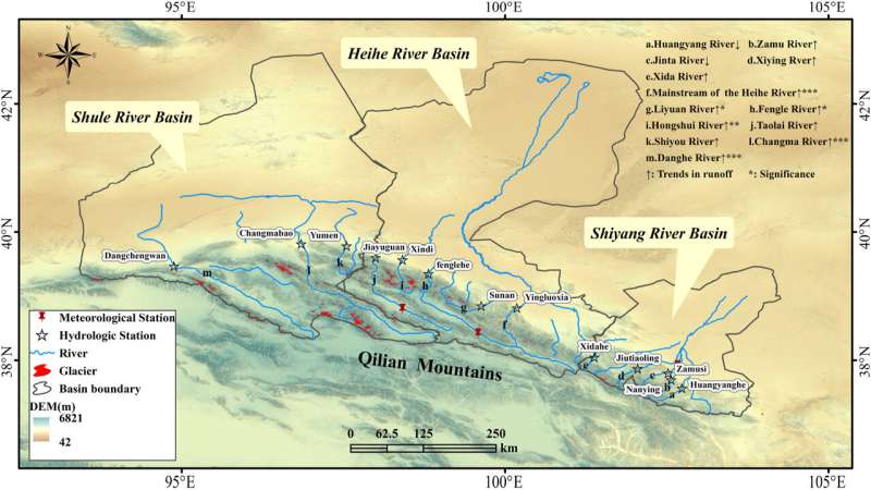
A research team from the Northwest Institute of Eco-Environment and Resources of the Chinese Academy of Sciences conducted a study on the outflow of 13 rivers in the Hexi Corridor, including the Shiyang River, the Heihe River, and the Shule River, to gain a deeper understanding of the runoff change of inland mountain rivers.
The study has been published in Research in Cold and Arid Regions,
The researchers used various indexes to analyze the annual runoff changes in the Shiyang River, Heihe River, and Shule River Basins. They compared spatial and temporal differences, explored sub-regional boundaries and runoff models in the Hexi Corridor inland river basin, and identified key time points of change.
The results show that the distribution of annual runoff in different river basins exhibits different trends of change.
The annual runoff of the Taolai River and its western tributaries, excluding the Shiyou River, has been increasing, while that of the eastern river has been decreasing. Despite these opposite trends, both the coefficient of variation and the complete regulation coefficient values (important indicators of runoff variability) for each river remain high.
The annual distribution of concentration periods in the Shiyang River basin is widely scattered, with a range exceeding 40°. Some rivers, such as the Huangyang River, have an even wider range of up to 93°, indicating a time difference of about three months for the occurrence of concentration periods. In contrast, the Heihe River basin has a narrower range of concentration periods, indicating a more concentrated distribution of runoff.
The concentration and timing of runoff in the Shule River Basin show significant variations, with distinct concentration periods observed at different times for the Shiyou River, Changma River, and Danghe River.
It is worth noting that since the beginning of the 21st century, these three basins have experienced a shift toward later concentration periods, suggesting that climate change has affected runoff distribution.
In addition, the researchers found that the kurtosis coefficient of the flow distribution curve is negative in the Liyuan River and the eastward rivers, indicating a smoother peak surface and a lower probability of extreme runoff events throughout the year.
Conversely, except for the Dang River, the western rivers have a positive kurtosis coefficient, suggesting a steeper peak surface and more concentrated runoff, which increases the risk of extreme runoff events.
The study provides an important basis for water resource planning and management in the Hexi Corridor and serves as a scientific reference for predicting future changes in regional water resources.
More information: Yan Luo et al, The changes in the annual distribution of mountain runoff during the period of 1965–2018 in Hexi Corridor, northwest China, Research in Cold and Arid Regions (2024). DOI: 10.1016/j.rcar.2024.04.001
Provided by Chinese Academy of Sciences


