March 7, 2024 feature
This article has been reviewed according to Science X's editorial process and policies. Editors have highlighted the following attributes while ensuring the content's credibility:
fact-checked
peer-reviewed publication
trusted source
proofread
Nearly 2 billion people globally at risk from land subsidence

Land subsidence is a geohazard caused by the sudden or gradual settling (years to decades) of the land surface due to the removal of subsurface material. This can be due to a variety of factors, both natural (such as earthquakes, volcanic activity and compaction of fine-grained unconsolidated sediments) and anthropogenic (for example, mining and groundwater abstraction). It poses a major issue in urban zones where it can cause building collapse and damage to infrastructure that may be a hazard to life and a resource management problem.
With an increase in land subsidence occurring in densely populated areas, a key factor driving subsidence is groundwater abstraction—the removal of water stored in the pore space of subsurface layers and transporting it away for human consumption and irrigation in agriculture, leading to compaction of the subsurface sediments.
This is the focus of new research, published in Geophysical Research Letters, in which scientists identified a significant positive correlation between the rate of groundwater abstraction and subsidence, meaning these areas should be a major focus of water resources management to alleviate this geohazard.
Tsimur Davydzenka, a Ph.D. researcher at Colorado School of Mines, U.S., and colleagues Dr. Pejman Tahmasebi and Professor Nima Shokri, turned to deep learning artificial intelligence to predict the scale of land subsidence globally. Explaining the significance of their research, Tsimur and Dr. Tahmasebi said, "Land subsidence is a destructive phenomenon that damages infrastructure and aquifers, as well as putting human lives at risk. Population growth has played an undeniable part in resource extraction that has led to subsidence.
"Based on our studies, we realized that several local studies in different countries exist that explore land subsidence but there is not sufficient research at the global scale. Such maps either do not provide any information about the magnitude of subsidence, which is more important than just the chance of observing it, or they are limited to regional scales. Using modern data-driven modeling techniques, we introduced the first global map of subsidence rates, which can be used to inform groundwater management policies and guide mitigation."
The researchers used existing data from land subsidence studies and remote sensing to generate a training dataset of 46,000 subsidence scenarios. Alongside a selection of 23 climatic, geographical and topographical conditions (including precipitation, soil composition, sediment thickness and slope) these were used to train a machine learning model, which was then able to estimate the total area of land at risk from subsidence and the population in these zones.
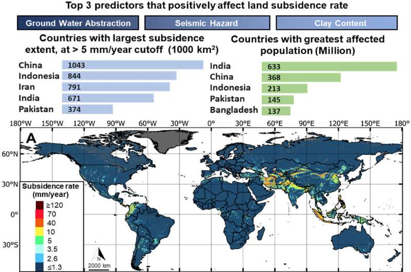
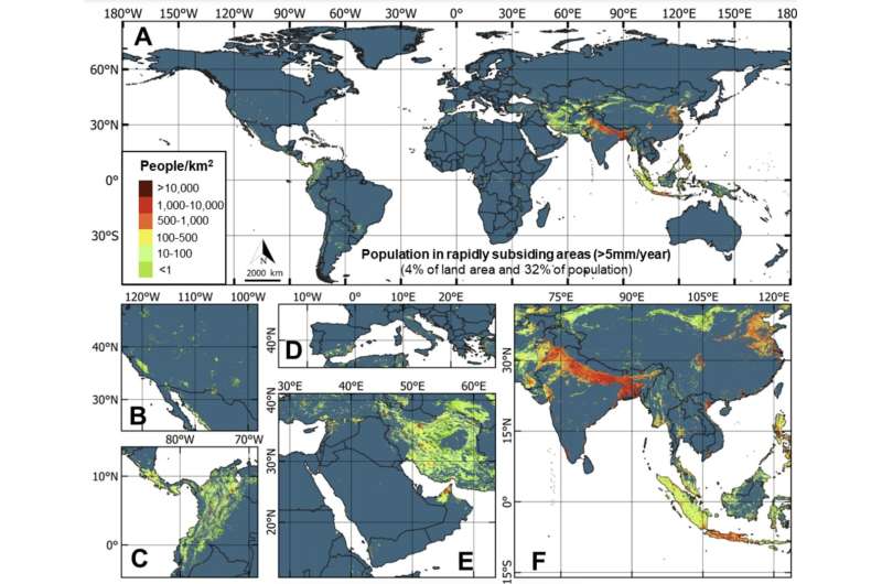
They determined that more than 6.3 million km2 of Earth's surface (~5% of total global land area) is susceptible to subsidence rates deemed significant enough to cause damage and require mitigation strategies—these being greater than 5 mm/y. This follows from previous work that had suggested 12 million km2 of land surface experienced subsidence rates of 430 mm/y. Of this more than 6.3 million km2, 231,000 km2 was identified in urban areas, where population density shows ~2 billion people (25% of global population) are located in these high-risk zones.

The machine learning model determined groundwater abstraction to be the main predictor of land subsidence, followed by seismic activity from earthquakes, then environmental conditions (namely precipitation) affecting groundwater recharge, sedimentary unit thickness (larger units having more space for ultimate compaction), mean temperature of warmest months (important for arid and semi-arid regions susceptible to subsidence), soil clay content, and population density.
Given groundwater abstraction is the primary concern, Tsimur and Dr. Tahmasebi suggest ways in which the global population's dependence on this could be modified in the future. "To minimize dependence on groundwater, strategic measures include promoting water use efficiency, implementing strict regulatory frameworks and incentivizing agricultural practices that optimize water consumption. Additionally, investing in water recycling and reclamation technologies can augment water availability without overreliance on groundwater.
"Phasing out groundwater extraction could be complemented by harnessing alternative sources such as treated wastewater, rainwater harvesting and stormwater management. However, the transition should also consider the spatial constraints of reservoirs and the economic feasibility of seawater desalination. By integrating conservation practices, using technological innovations and diversifying water sources, a sustainable water supply ecosystem can be established, mitigating the environmental and socioeconomic challenges associated with excessive groundwater abstraction."
Regarding the sediments most affected by subsidence, 3.8 million km2 of unconsolidated sediments (10% of global extent) were identified as being primary risk, with the highest subsidence rates of 320.6 mm/y. Cultivated land constituted the largest expanse under threat, at 2.1 million km2 worldwide (12.2% of global cultivated land), while subtropical highlands and temperate oceanic climates experienced enhanced subsidence rates greater than 50 mm/y.
Overall, South Asia is modeled to have the greatest extent of land under threat of subsidence (2.2% of its total area experiencing subsidence rates greater than 50 mm/y) as well as the largest number of people to be affected by it (20 million). Other countries with subsidence rates exceeding 50 mm/y include the Philippines, Iran, Costa Rica, Indonesia and Uzbekistan.
While this research provides an important global map of land subsidence which will help businesses, farmers and local authorities in areas at higher risk plan for challenges they may experience in the future, further fine-tuning of the model is required. As such, Tsimur and Dr. Tahmasebi state that it is "certainly possible" that future models could be at a high enough resolution for individual local authorities to use the data for mitigation strategies.
For example, given the significance of groundwater abstraction in the dataset, including greater detail on the depth of abstraction, aquifer type, the lag between abstraction and groundwater table decline, as well as the interplay of the oil and gas industry (contributing to 4.36% of current subsidence records), are necessary steps to enhance this vital work. With increasing population augmenting our dependency on groundwater and climate change enhancing droughts, the impact of groundwater decline on land subsidence will continue to be an ever-pressing issue in years to come.
More information: Tsimur Davydzenka et al, Unveiling the Global Extent of Land Subsidence: The Sinking Crisis, Geophysical Research Letters (2024). DOI: 10.1029/2023GL104497
Journal information: Geophysical Research Letters
© 2024 Science X Network


