February 5, 2024 feature
This article has been reviewed according to Science X's editorial process and policies. Editors have highlighted the following attributes while ensuring the content's credibility:
fact-checked
peer-reviewed publication
trusted source
proofread
Mapping Australia's marine estate: Seafloor surveillance for biodiversity management

Global marine biodiversity is continually being threatened by oceanographic changes linked to both global warming and anthropogenic activities that degrade the ambient environment for marine organisms. Australia's oceanographic biodiversity is globally admired, with new initiatives being undertaken to aid conservation of marine ecosystems for decades to come, both at the local and global scale.
This feeds into a global initiative, the Ocean Decade, which aims to transform our planet's marine landscape for the better by 2030, including eliminating ocean pollution, mapping ecosystems, targeting marine hypoxia (depleted oxygen concentrations), sustainably harvesting food to support society and protecting communities from ocean hazards (such as tsunamis).
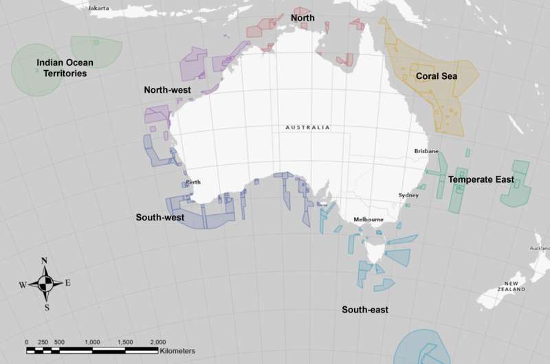
Extending up to 200 nautical miles (~370 km) from Australia's entire coastline, the Exclusive Economic Zone encircles the continent, with almost half of it containing protected areas known as Australian Marine Parks. These parks have recently become the focus of enhanced monitoring to identify key pressures facing the organisms inhabiting them, encouraging implementation of new stewardship strategies.
New research published in Frontiers in Marine Science has turned to seabed mapping to generate habitat maps that can be monitored over decades to identify significant changes that may pose hazards to local wildlife.
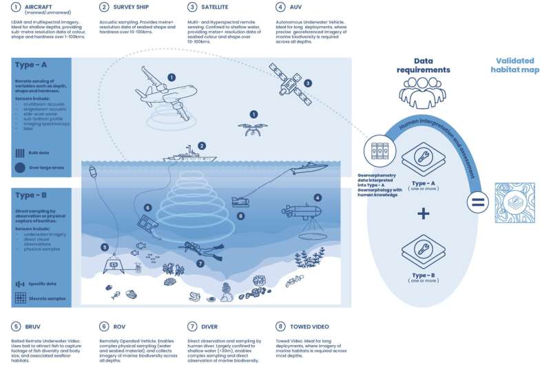
The AusSeabed program is a national initiative launched in 2018 that compiles bathymetric data (the underwater equivalent of topography, studying the depths of ocean floors) to produce geomorphometric maps that can be used to predict the scale and location of particular biological assemblages, as well as differences in them over time.
With previous research suggesting topographic features in the ocean can impact the thermal and nutrient mixing of the ocean up to 1 km away, this is particularly useful in the case of deep-sea benthic communities that may otherwise be challenging to monitor in the comparatively inhospitable environments.

Dr. Vanessa Lucieer, Associate Professor at the University of Tasmania, and colleagues produced geomorphometric maps for 37 of Australia's 61 Marine Parks, a quantitative approach to assessing the landforms comprising the seafloor. The bathymetric data covered ~58% of the marine parks' area, reaching up to ~86% on some of the continental slopes where greater exploratory focus had previously occurred.
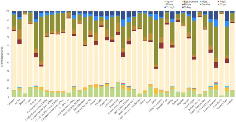
Geomorphometric characteristics of the maps were split into 10 classes: peak, ridge (elongate high point), trough (elongate, wide and flat-bottomed channel), plane (flat surface), hole, valley, slope, apron (a gentle slope at the base of an elevated high point), escarpment (steep slope between shallow slopes) and saddle (broad dip within an elevated high point).
Across the marine parks, plane was the most common bathymetric feature (~58%), followed by slope at ~18%, with apron, saddle and valley accounting for up to 8% of the mapped area. For the marine parks in the south-west and south-east, plane seafloor was up to ~33% less prevalent compared to all of the other zones, instead seeing an increase in ridges, troughs and valleys.
Furthermore, there was a pronounced difference in bathymetric features by depth zone, with the research team selecting two key focuses in the mesophotic (~30 m–70 m) and upper-slope (200 m–700 m). Only 24 of the 37 marine parks have bathymetric data in the mesophotic zone, 16 of which were dominantly plane with small sections of slope and apron, while the other eight had highs and lows with interspersed ridges, peaks, holes and valleys. Conversely, the deeper upper-slope zone had a much more varied profile across all of the different bathymetric features.

Understanding the different bathymetric profiles through the ocean enables targeted management strategies for each unique marine park, while identifying those with similar characteristics means effective measures and resources can be shared between them.
The mesophotic zone, along with the rariphotic zone (70 m–150 m depth), are key habitats for fish and therefore under pressure from industrial fishing practices. Determining fish habitat preferences within these zones therefore means policymakers can target conservation efforts in the right areas to protect both the natural world and sustainable food supply.
Similarly, ridges are known to be points of high biodiversity, so identifying their location around Australia, which is already at risk from enhanced marine degradation, is a key driver to target efforts for conserving habitats and the organisms inhabiting them there.
Though this research marks an important first step in using geomorphometrics for ecosystem monitoring and management, it is inherently biased by the quality and coverage of bathymetric data available, which needs to be an additional focus for data acquisition moving forward.
While efforts to conserve Earth's marine world are ever-growing, they are continually being challenged by the fast pace of transformation in the oceans, and scientists must continue this impactful work in order to seek the positive shifts needed to ensure our oceans will thrive for centuries to come.
More information: Vanessa Lucieer et al, Geomorphometric maps of Australia's Marine Park estate and their role in improving the integrated monitoring and management of marine ecosystems, Frontiers in Marine Science (2024). DOI: 10.3389/fmars.2023.1302108
Journal information: Frontiers in Marine Science
© 2024 Science X Network


