August 2, 2023 dialog
This article has been reviewed according to Science X's editorial process and policies. Editors have highlighted the following attributes while ensuring the content's credibility:
fact-checked
trusted source
written by researcher(s)
proofread
Evidence for rainfall-triggered seismicity in intraplate domain at the earthquake of 11 November 2019 in France

On 11 November 2019, a surface-rupturing earthquake occurred at a very shallow depth (about 1 km) near Montélimar city, along the Rhône Valley in southeast France. The earthquake caused significant damage in the villages of Le Teil and Saint-Thomé, with the partial collapse of hundreds of old houses built with ancient stones and damage to sites of historical and religious heritage.
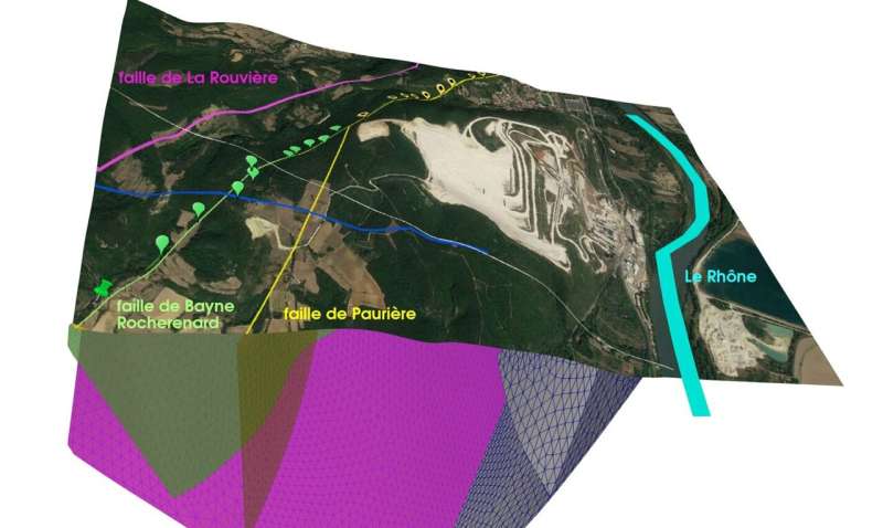
The question was raised shortly after about the potential influence of a nearby surface quarry. In contrast to a purely mechanical view, we investigated in this study the hypothesis of "hydroseismicity" developed by John K. Costain (1930–2015), assuming that this earthquake was triggered by the impact of meteoric water transfer from the ground surface. We simulated the hydraulic recharge linked to the infiltration of water in the fault zones in the decade preceding the earthquake.
We verified via a double-permeability model that the intersections between two or multiple faults were the most probable location zones for the hypocenter of an earthquake triggered by a hydraulic recharge. We finally compared this estimated hydraulic overpressure to the impact of stress transfer from the ground surface due to the extraction of rocks from the surface quarry over about two centuries.
Two separate numerical modelings (mechanical and hydraulic) of the same structural geology
The scientists, working on a research program in partnership with the quarry owner, conducted pure mechanical modeling to take into account not only the evolution of the surface topography, but also the history of excavated volumes of rocks since 1850.
The study was carried out in two stages. From January to December 2020, the first program involved constructing the first 3D geological model of the area using two new seismic lines and field observations (including a new interpretation of InSAR data acquired via Sentinel-1 satellite). This work combining geology and geophysics was completed by the first two-dimensional hydraulic simulations (2D vertical).
Surface soil moisture data acquired by the European SMOS satellite and modeling of unsaturated zone height variations using the ComPASS code showed that the water infiltration had an impact on piezometric levels, with maximum hydraulic overpressures at the fault intersections.
The second phase of the study, from February to May 2021, confirmed and refined the results of the initial stage, particularly with regard to the location of the zone of maximum hydraulic overpressure (at the intersection of the three-fault system). The best estimation of the overpressure at depth was calculated by using in situ soil moisture (at a 30 cm depth) as surface conditions during the period 2015–2019 before the seismic event.
Comparison of two potential triggering factors
The two separate numerical approaches that were carried out by the researchers show that the hydraulic effect is about 2.5 times larger than the cumulative effect of mechanical stress release due to the mass removal from the surface quarry. The researchers show that, while the tectonic origin for the Le Teil earthquake is not in doubt, it may have been triggered by intense rainfalls in the month preceding the seismic event. This study suggests a rapid hydraulic triggering mechanism on an intersection of faults at a shallow depth.
This highly original, transdisciplinary project, combining geology, geophysics, geomechanics, seismology and hydrogeology, opens up a new field of research into hydroseismicity in the context of a possible evolution of the dynamics of the hydrologic cycle due to climate change.
Such hypotheses on hydroseismicity in the intraplate domain had already been advanced in the U.S. and China over the past 20 years; it was here confirmed in mainland France.
More broadly, this earthquake not only revealed the need to reassess the hazard in this area in the vicinity of industrial facilities in the Rhône Valley, but also launched a French debate on the risk of surface-rupturing shallow earthquakes in sensitive areas (including nuclear power plants).
This story is part of Science X Dialog, where researchers can report findings from their published research articles. Visit this page for information about ScienceX Dialog and how to participate.
More information: André Burnol et al, Impacts of Water and Stress Transfers from Ground Surface on the Shallow Earthquake of 11 November 2019 at Le Teil (France), Remote Sensing (2023). DOI: 10.3390/rs15092270
Bio: André Burnol has more than 20 years of experience in hydrogeochemistry, and his research concerns the coupling of physical and (bio)geochemical processes controlling the mass transfer between water, gas and solid phases in porous media. He defended a doctorate in environmental geochemistry at the Grenoble University on the mobility of arsenic in the aquifers of the delta of Bengal. His current research concerns the assimilation of satellite-derived soil moisture in subsurface models.


